 Encyclopedia
The first boats leave Fraserganj long before sunrise.
The fishing harbour wakes quietly.
Diesel engines rumble to life one after another.
Fishermen move through the darkness carrying rolled nets, coiled ropes, and baskets stacked neatly along the wooden jetty. Above them, gulls stir briefly before disappearing into the fading night.
Within minutes, the mainland begins slipping behind.
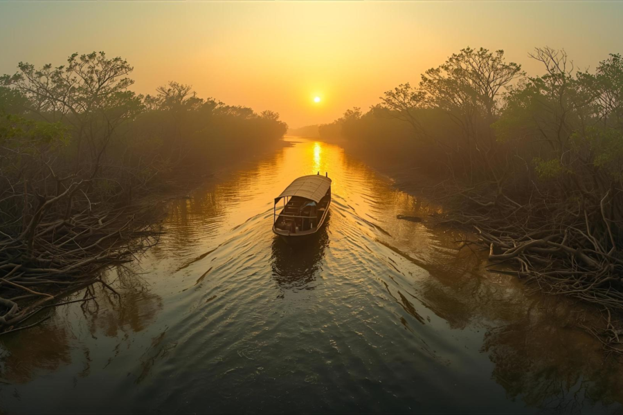
The boat heads south across the tide, where the familiar shoreline slowly dissolves into open water. Here, the Bay of Bengal and the lower Sundarbans seem to merge into one restless landscape. The air grows sharper with salt, and the only sounds are the steady pulse of the engine and the rhythm of waves against the wooden hull.
For a long time, there is nothing but water.
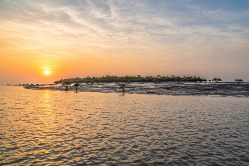
The horizon remains empty, interrupted only by distant fishing boats moving silently toward their own destinations. A Brahminy Kite glides overhead, while small flocks of gulls skim low across the tide before vanishing into the morning haze.
Then, almost without warning, a dark line appears ahead.
At first, it seems like another distant bank of cloud. Gradually, it separates from the horizon.
Low mangroves take shape.
Patches of exposed mud emerge as the tide retreats.
The island rises only slightly above the sea, so low that it almost seems borrowed from the water itself.
This is Jambudwip.
Unlike many islands of the Sundarbans, it does not announce itself with villages, embankments, or ferry ghats. It appears quietly, blending into the shifting colours of tide and sky.
The boat slows as the water grows shallower.
The tide decides where the journey ends and the exploration begins.
Stepping ashore is only the beginning. The real story of Jambudwip waits beyond the shoreline, where every tide has shaped a different chapter and every season leaves the island looking slightly different from the last.
First Encounter
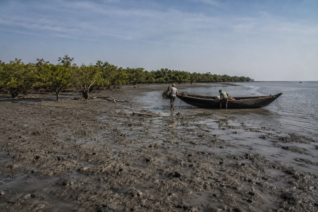
The first true encounter with Jambudwip begins at the shoreline.
Not because the coast is dramatic.
But because it feels exposed.
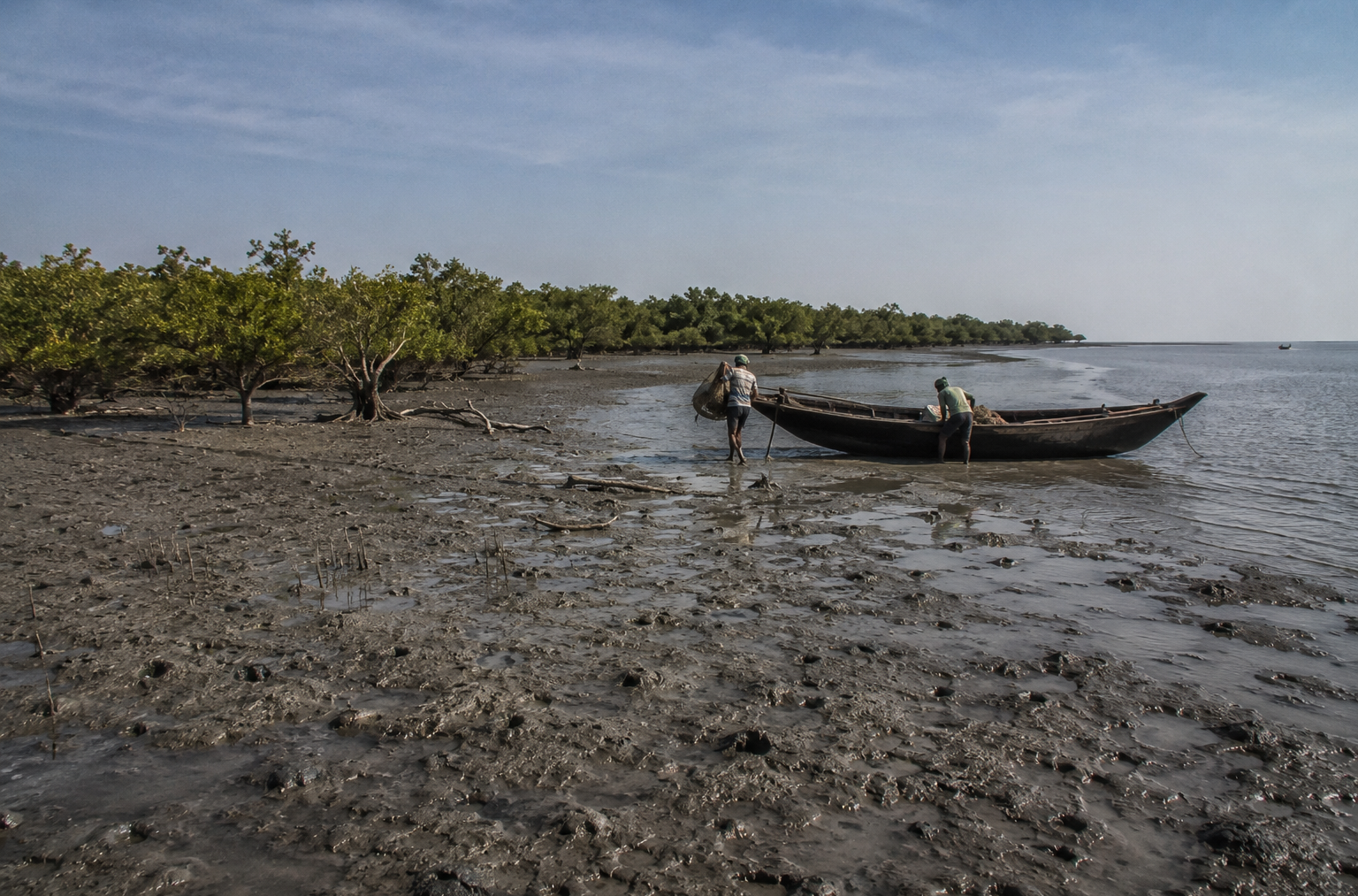
There are no protective hills here. No stone embankments rising above the tide. The island lies low against the Bay, vulnerable to wind from every direction. During high tide, portions of the shoreline almost disappear beneath the water. During low tide, enormous mudflats emerge outward into the sea like freshly uncovered land.
The coast changes character hour by hour.
Near the landing zone, the ground is thick with marine sediment.
- Each footstep sinks slightly before finding resistance.
- Tiny crab tunnels puncture the mud everywhere.
- Broken shell fragments glimmer in the morning light.
- The mangroves begin only a little farther inland.
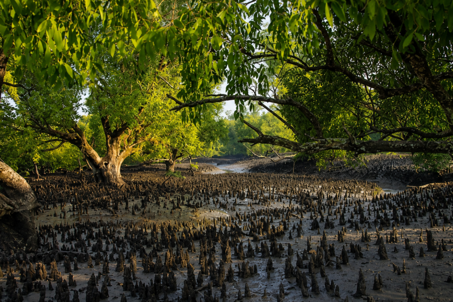
They are shorter here than in deeper Sundarbans forests, shaped constantly by salt-heavy wind and coastal exposure. Goran and Gewa cluster tightly near the wetter stretches. Their roots grip unstable sediment that storms attempt to strip away every monsoon.
The wind never truly stops.
Even on calmer mornings, air moves steadily across the island, carrying the smell of fish, wet rope, tidal mud, and distant seawater. Clothing absorbs the salt within minutes.
During the active fishing season, traces of temporary human occupation become visible almost immediately.
- Bamboo poles rise from the flats in uneven rows.
- Fishing nets dry across makeshift frames.
- Tarpaulin shelters stand low against the wind.
Plastic drums, rope coils, wooden crates, and fish baskets lie scattered near working zones shaped entirely by labour rather than planning.
Nothing is decorative.
Everything is practical.
Jambudwip historically functioned less like a settlement and more like a temporary marine camp repeatedly assembled and dismantled according to season.
That atmosphere still lingers across the island.
Walking farther from the shore reveals flattened clearings where fish drying once dominated daily life during the winter months. Even when empty, these spaces feel used. Hardened pathways cut across the sediment toward older landing points. Weathered bamboo fragments remain embedded in mud long after temporary structures disappear.
The island preserves memory through traces.
Silence behaves strangely here.
On inhabited Sundarbans islands, sound usually arrives continuously — schoolchildren, ferry horns, market noise, bicycle bells, distant loudspeakers, temple music drifting over embankments.
Jambudwip sounds emptier.
- Wind becomes the dominant presence.
- Then birds.
- Then water.
At low tide, one can hear mud itself cracking softly beneath sunlight as trapped moisture evaporates from exposed flats. Gulls scream overhead before dropping suddenly toward shallow pools where fish remain stranded by retreating water.
Farther away, boat engines pulse across open tidewater.
The sky feels enormous over the island.
Without dense settlement or tall structures, nothing interrupts the horizon for long. Cloud formations become part of the landscape itself. In winter, the light stays sharp and metallic across the mudflats. Before storms, the sky darkens quickly over the Bay, flattening the entire island beneath heavy marine weather.
Everything about Jambudwip reinforces vulnerability.
And yet, historically, people kept returning.
That becomes difficult to ignore while standing here.
The island offers almost none of the comforts associated with stable settlement — limited freshwater, severe weather exposure, unstable shoreline conditions, and isolation during rough seas.
But it offered something else.
Access.
- Access to marine fishing grounds.
- Access to wind suitable for drying fish.
- Access to seasonal economic survival.
That practical relationship shaped every visible detail on the island.
Island Identity
Jambudwip belongs to the southern edge of the Indian Sundarbans near the Bay of Bengal, southwest of Fraserganj and Bakkhali in the South 24 Parganas district of West Bengal.
But geography alone does not explain the island.
Its real identity comes from absence.
- No permanent village.
- No year-round civilian population.
- No agricultural landscape spreads behind embankments.
For most of the year, Jambudwip remains nearly empty except for birds, mangroves, tidal movement, and shifting weather moving inland from the sea.
Then winter transforms it.
Historically, fishermen from coastal Bengal travelled here seasonally during productive marine fishing months. Temporary camps appeared across the island.
Boats lined the muddy shore.
Fish drying operations spread over open windy flats where marine catch could be preserved efficiently beneath salt-heavy air.
The island became a seasonal fishing civilization.
- Not permanent enough to become a town.
- Too economically important to remain ignored.
That distinction makes Jambudwip unlike most other islands in the Sundarbans.
Elsewhere in the delta, islands are usually defined by settlement:
- villages
- agriculture
- embankments
- migration histories
- market roads
- schools
- religious structures
Jambudwip developed through marine movement instead.
Everything here historically revolved around the tide and labour.
- Fishing crews arrived during the season.
- Temporary shelters were built.
- Work intensified for months.
- Then people departed again.
The island expanded socially and contracted socially according to the marine calendar.
Its physical landscape reflects that impermanence everywhere.
- No permanent masonry neighbourhoods are dominating the shoreline.
- No large civic infrastructure claims control over the land.
Even the pathways feel temporary, reshaped repeatedly by weather and seasonal occupation.
The Bay of Bengal remains the island’s strongest architect.
- Cyclones reshape their edges.
- Storm surges flood its flats.
- Salinity controls vegetation.
- Tides redraw sections of shoreline daily.
- Human presence adapts rather than dominates.
Officially, Jambudwip falls under protected forest administration within the broader Sundarbans ecological zone. Over time, conservation concerns surrounding mangrove protection and ecological sensitivity created tension with historical fishing activity on the island.
That conflict became central to Jambudwip’s modern identity.
To conservation authorities, the island represented a fragile coastal ecology requiring protection.
To fishing communities, it represented an inherited livelihood space tied to generations of marine labour.
The debate transformed Jambudwip into more than a geographic location.
It became a symbol of the larger Sundarbans dilemma: How to balance ecological protection with human survival in vulnerable delta landscapes.
Even today, the island feels suspended between those two realities.
- Wild and worked.
- Protected and remembered.
- Empty and historically crowded.
That layered identity gives Jambudwip its unusual emotional atmosphere. The island never feels fully abandoned.
But it never feels fully settled either.
The Rivers That Shaped The Island
Around Jambudwip, rivers lose their certainty.
Channels split unexpectedly through mudflats before dissolving into wider tidal water. During low tide, narrow creeks emerge across exposed sediment like temporary veins. Hours later, much of that landscape disappears again beneath incoming water from the Bay.
Nothing stays fixed for long.
The island exists where the estuarine Sundarbans waters begin surrendering themselves to the sea.
- Salinity remains high.
- Marine influence dominates daily life.
- Storm systems arriving from the south encounter little resistance before striking the exposed coast.
These waters created Jambudwip’s entire historical purpose.
Fishing communities did not come here searching for fertile agricultural land. They came because the surrounding marine-estuarine channels connected directly to productive fishing zones across the northern Bay of Bengal.
Water was a livelihood.
- Transportation.
- Risk.
- Memory.
Every object historically used on the island arrived by boat:
- nets
- salt sacks
- bamboo poles
- drinking water containers
- fuel
- food supplies
The tides controlled movement completely.
Boats’ timed departure according to the current direction. Returning vessels calculated landing against changing water depth near muddy shorelines. During poor weather, crews sometimes waited offshore for safer tidal conditions before approaching the island.
Older fishermen learned these waters through repetition rather than maps.
- Water colour could reveal sediment shifts.
- Bird movement sometimes signalled fish activity.
- Sudden wave texture changes warned of hidden mudbanks beneath the surface.
After cyclones, familiar channels occasionally vanished altogether. This constant environmental instability shaped the psychology of the island.
Time itself behaved differently here. Not by clock alone.
But by tide.
- Morning ebb.
- Evening flood.
- Moon phase.
- Wind direction.
- Storm pressure.
The rivers around Jambudwip were never passive geography.
They were active forces shaping settlement, economy, danger, and survival. Even silence changes with the water level.
At low tide, exposed flats stretch outward from the island in dark, shimmering expanses alive with crabs and feeding birds. Water drains slowly through mangrove roots with faint sucking sounds.
At high tide, the sea returns aggressively.
- Currents thicken.
- Waves strike muddy banks.
- Loose boats knock against bamboo moorings.
The island shrinks visually beneath rising water.
Everything expands and contracts here according to tidal rhythm. That is why Jambudwip still feels unfinished.
The surrounding rivers and tidal channels never stop remaking it.
Historical Footprints
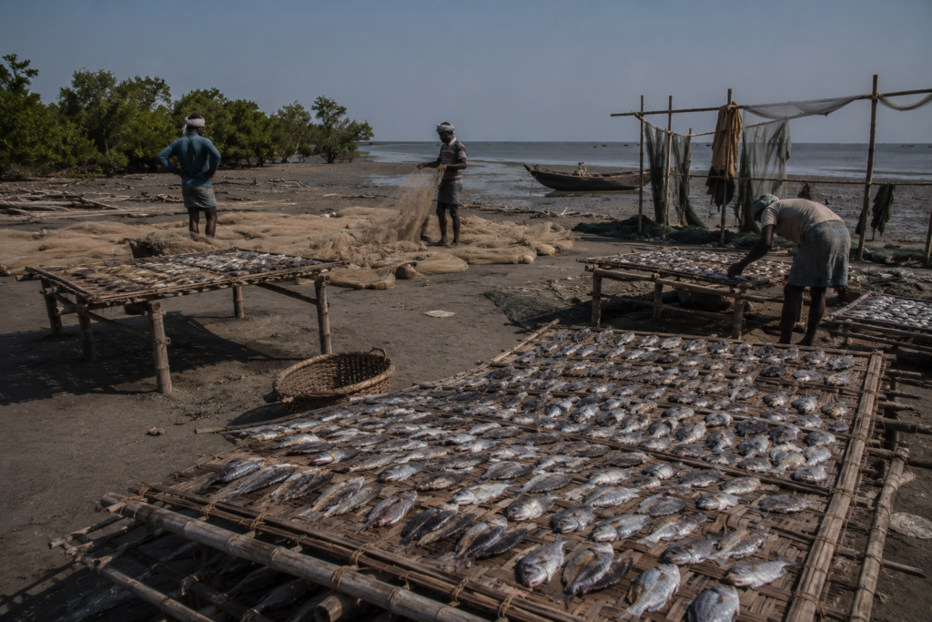
By late morning, the island begins revealing older layers beneath the silence.
- Not through ruins.
- Not through monuments.
Jambudwip preserves history differently.
Its past survives in tidal routes, fishing memory, disputed forest records, and the repeated seasonal movement of people who returned here year after year, long before the island entered conservation debates.
Standing near the old drying grounds during low tide, it becomes easier to understand why fishermen once considered this exposed stretch of land indispensable.
The wind matters here.
It moves continuously across the island from the Bay, carrying dry saline air ideal for preserving fish. Open flats provide space impossible to find in crowded mainland settlements. Nearby waters connect directly to productive marine fishing zones. Even the island’s harshness became economically useful.
Jambudwip was never comfortable.
It was strategic.
Long before environmental restrictions transformed the island into a contested protected zone, seasonal fishing communities treated it as part of a larger marine world stretching across coastal Bengal.
Boats arrived from Kakdwip, Namkhana, Fraserganj, and other fishing settlements along the southern delta. Older accounts also connect parts of this fishing culture to migrants from Chittagong and Noakhali after Partition reshaped the eastern coastline of Bengal.
Many of these communities carried specialized marine knowledge.
- Not river fishing.
- Sea fishing.
- That distinction mattered.
The lower Bay demanded different nets, different timing, different navigation skills, and different tolerance for risk. Fishermen working around Jambudwip often spent weeks away from mainland settlements, living inside temporary camps shaped entirely around labour and tide.
The island itself remained mostly transitional ground.
Work happened constantly.
Fish arrived from offshore catch zones before sunrise. Crews unloaded baskets directly onto muddy flats. Sorting began immediately under the open sky. Some caught travelled inland fresh. Large quantities were cleaned, salted, and spread across bamboo drying racks where wind and sun slowly transformed them into preserved stock for regional trade networks.
By noon, the smell could dominate the entire shoreline.
- Salt.
- Fish oil.
- Smoke.
- Marine decay.
Drying flesh in the sunlight.
For outsiders, the atmosphere often felt overwhelming.
For fishing communities, it meant livelihood.
The seasonal camps historically built on Jambudwip were never intended to resemble permanent villages. Bamboo poles formed the skeleton of temporary shelters covered with tarpaulin, woven mats, or plastic sheeting. Cooking spaces remained communal. Water storage became essential because freshwater access on the island was limited.
Everything revolved around efficiency.
The fishing season was short.
The weather remained unpredictable.
And storms could erase months of preparation in hours.
By the 1960s and 1970s, Jambudwip had already become well known as a major fish drying centre along the Bengal coast. During peak winter activity, portions of the island reportedly transformed into enormous seasonal workspaces where labour continued from dawn until nightfall.
Then the ecological politics surrounding the Sundarbans began changing.
Officially, Jambudwip had long been classified as reserve forest land. But enforcement intensified gradually as conservation concerns around the Sundarbans expanded during the late twentieth century. Mangrove destruction, habitat pressure, and human encroachment became increasingly sensitive issues within protected coastal ecosystems.
From the perspective of forest authorities, seasonal occupation threatened the fragile ecological balance.
From the perspective of fishing communities, the island represented an inherited working ground tied directly to survival.
That conflict slowly transformed the island’s history.
By the 1990s, tensions between fisher groups and forest administration had become increasingly visible. Restrictions on occupation and fish drying operations generated protests and legal disputes. Environmental organizations argued for stronger ecological protection. Fishing communities argued that their relationship with the island predated many modern conservation frameworks.
The debate surrounding Jambudwip eventually became symbolic of a larger Sundarbans question:
Can vulnerable ecosystems be protected without erasing the human histories already woven into them?
Walking across the island today, traces of that unresolved tension remain everywhere.
- Abandoned bamboo fragments emerge from mud after erosion.
- Flattened clearings suggest former drying grounds.
- Old landing stretches still bear signs of repeated seasonal use.
The island does not feel untouched.
It feels interrupted.
That interruption defines much of Jambudwip’s modern story.
Unlike historic settlements that preserve continuity through architecture, Jambudwip preserves continuity through return. Generation after generation of fishermen memorized the same tidal approaches, rebuilt similar temporary camps, and worked the same seasonal waters despite storms, shifting regulations, and changing coastlines.
Even absence became cyclical.
When fishing season ended, boats departed one by one. Drying racks were dismantled or abandoned. The island slowly emptied back into wind and mangrove silence. Birds reclaimed exposed flats. Tides erased footprints.
Then months later, people returned again.
That rhythm lasted for decades.
Perhaps longer.
And because the island never developed into a conventional settlement, its history still feels unusually close to the weather. Storms mattered more here than politics. Tides shaped memory more deeply than roads ever could.
Jambudwip’s past survives less as a documented chronology and more as repeated human movement across fragile land at the edge of the Bay.
Historical Personalities & Transformations
Jambudwip does not possess the kind of historical personalities usually associated with famous islands.
There are no zamindar mansions here. No major reform movements were rooted in permanent settlements.
No celebrated temple founders or colonial administrators whose names dominate local memory.
The island’s defining figures were workers.
- Boatmen.
- Net makers.
- Dry-fish traders.
- Seasonal fishermen.
People whose knowledge rarely entered official archives.
Yet their influence shaped the marine culture of coastal Bengal.
Older fishing communities working around Jambudwip developed systems of navigation and seasonal occupation adapted specifically to the exposed waters near the Bay of Bengal. Survival here depended less on ownership than on environmental intelligence.
A fisherman needed to understand:
- wind direction
- tidal timing
- storm behaviour
- seasonal fish movement
- and changing mudbanks
Mistakes carried immediate consequences.
This practical knowledge was passed orally across generations.
Fathers taught sons how to read currents by watching floating debris. Crews learned where tidal channels deepened after cyclones. Older navigators could sometimes estimate approaching weather simply from subtle shifts in wind texture over open water.
That inheritance became part of the island’s invisible history.
The biggest transformation in Jambudwip’s story arrived not through settlement expansion, but through changing environmental governance.
For decades, the island functioned primarily as a seasonal marine workspace. Then, conservation frameworks surrounding the Sundarbans expanded rapidly during the late twentieth century.
Protected forest policies reshaped the island’s future.
Human activity that once appeared economically normal increasingly became categorized as ecological pressure. Fish drying operations, temporary camps, wood use, and seasonal occupation all entered the environmental debate.
The island’s identity began changing in the public imagination.
Older generations remembered Jambudwip as a working island.
Newer narratives increasingly described it as a protected ecological territory.
Both perspectives contained truth.
That duality remains unresolved even now.
Walking along the shoreline today, one can still sense traces of the earlier labour world beneath the quieter ecological landscape. Certain landing areas remain visibly shaped by repeated boat access. Open clearings suggest former drying activity. Weathered bamboo occasionally appears after heavy rain exposes buried sediment.
The island remembers through fragments.
Perhaps the most significant transformation of all has been psychological.
Historically, Jambudwip represented opportunity despite hardship. Seasonal work here supported families across coastal Bengal. The island existed within a larger fishing economy tied to migration, trade, and inherited marine labour.
Today, it is increasingly viewed through another lens: fragility.
- Climate vulnerability.
- Conservation sensitivity.
- Coastal erosion.
- Cyclonic exposure.
The shift reflects broader changes unfolding across the Sundarbans itself.
Landscapes once treated primarily as productive frontiers are now understood simultaneously as endangered ecological systems.
Jambudwip stands directly inside that transition.
Folklore & Legends
By afternoon, the wind over the island changes.
The tide begins turning inland again. Water creeps slowly back across the flats. Birds lift from exposed mudbanks before settling farther toward quieter creeks near the mangroves.
This is usually when older fishermen begin speaking more freely.
Not always about the island itself.
But about the waters around it.
Across the Sundarbans, folklore travels with people rather than geography. Even temporary fishing camps carried entire worlds of belief into exposed coastal landscapes like Jambudwip. Men arriving seasonally from Fraserganj, Namkhana, Kakdwip, and farther east brought with them stories already woven deeply into delta life.
Bonbibi remained central.
Protector of forest workers, honey collectors, woodcutters, and fishermen across the Sundarbans, Bonbibi occupied a spiritual territory somewhere between religion and survival psychology. Before long fishing journeys, many crews performed small rituals asking for safe passage through unpredictable waters.
Out near Jambudwip, those prayers often felt practical rather than symbolic.
The Bay could change suddenly.
- Fog erased visibility.
- Storms formed without warning.
- Boats disappeared.
- Men drowned.
In landscapes where survival depended partly on forces beyond human control, belief became another form of preparation.
Dakshin Ray — the tiger-associated spirit figure feared across the Sundarbans — also existed within the imagination of many fishing communities, though Jambudwip itself was never known primarily as tiger territory. Still, the wider mangrove world remained psychologically connected. Fishermen moving through tidal creeks at dawn or returning after dark often carried the same inherited caution found deeper inside forest zones.
Some stories focused less on tigers and more on water itself.
- Strange lights over tidal flats.
- Voices heard during fog.
- Boats appear briefly through the mist before vanishing again.
Whether these accounts emerged from exhaustion, weather distortion, fear, or folklore mattered less than the atmosphere they created.
The sea around Jambudwip encouraged uncertainty.
At night, distances become difficult to judge. Sound travels strangely over open water. Wind shifts direction without visible warning. The island’s low landscape offers few fixed landmarks once darkness settles across the Bay.
Even experienced fishermen sometimes described the waters here with caution.
Not supernatural fear exactly.
Respect.
One older boatman from Fraserganj reportedly described Jambudwip as “a place the sea borrows every year.”
The phrase lingered because it captured something deeper than folklore.
Nothing here feels permanently possessed by humans.
- The camps disappear.
- The shore changes.
- Mudbanks dissolve.
Even pathways vanish after monsoon tides.
Perhaps that instability itself shaped the island’s mythology more than any single legend.
Jambudwip became part of the larger emotional geography of the Sundarbans — a place where land remains temporary, weather remains powerful, and human certainty never lasts very long.
Life Between The Tides
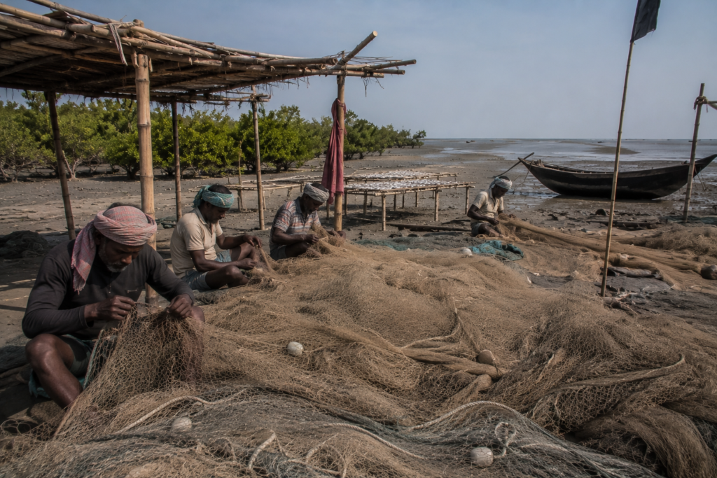
By midday during the active fishing season, Jambudwip historically became almost entirely a landscape of labour.
The shoreline filled first.
Boats arrived continuously through the morning tide carrying marine catch from surrounding waters. Men jumped directly into mud, carrying baskets balanced against their shoulders, slick with saltwater and fish oil. Nets spread across open ground in tangled grey heaps waiting for repair before the next departure.
There was little stillness during working hours.
Every part of the island operated according to tidal urgency.
Fish could not remain unsorted for long under the coastal heat. Drying racks needed constant maintenance. Incoming weather had to be monitored carefully. Salt supplies required protection from sudden rain.
The workday began before sunrise and often continued well after dark.
Dry fish production formed the centre of this seasonal economy.
Across open windy stretches of the island, bamboo platforms and raised frames held rows of fish laid carefully beneath the sun. The smell travelled enormous distances. During peak activity, entire sections of the island carried the sharp, heavy scent of drying marine catch mixed with smoke from cooking fires and diesel from returning boats.
The labour itself was physically exhausting.
- Hands remained permanently coated in salt.
- Clothing stiffened from sea air.
- Skin cracked under continuous exposure to the sun and wind.
And yet fishermen returned season after season because the island remained economically important.
Temporary camps developed their own rhythms.
Cooking usually happened collectively.
Rice boiled in large metal pots blackened underneath from repeated use over wood fires. Dried fish, fresh catch unsuitable for trade, lentils, onions, and green chillies formed the basis of most meals.
Freshwater was precious.
Every container mattered.
During difficult weather, supply boats could be delayed for days.
Afternoons often became the harshest part of the day.
The exposed flats reflected heat upward with almost blinding intensity. Work slowed slightly during peak sunlight, though repairs continued constantly. Torn nets had to be stitched. Bamboo supports are reinforced. Boats are inspected before evening departure.
Children occasionally accompanied families during earlier decades, learning marine labour through observation long before adulthood. Knowledge passed practically:
- How to tie nets
- How to judge the tide
- How to spot weather changes
- How to survive rough crossings
The island functioned like a seasonal apprenticeship in endurance.
And everywhere, the tide remained the real clock.
- Low water exposed more working ground.
- The incoming tide interrupted the movement.
- Storm surges could erase entire sections of activity overnight.
Nothing here allowed people to forget the sea for long.
By evening, exhaustion settled visibly across the camps. Smoke rose from cooking fires into salt-heavy dusk air. Fishing crews prepared again for night departures. Some boats left immediately under a moonlit tide, while others waited for better current conditions before pushing back into open water.
Then, gradually darkness reclaimed the island.
Only temporary lights remained visible near the camps.
Beyond them stretched mangroves, mudflats, tidewater, and the enormous black horizon of the Bay of Bengal.
Walking Through The Villages
Jambudwip has no permanent village in the ordinary sense.
That becomes increasingly clear while walking inland from the shoreline.
There are no concrete lanes cutting between settled neighbourhoods. No school walls painted with fading government slogans. No cycle repair shops, grocery stalls, or crowded tea corners where conversations drift lazily through the afternoon.
And yet, during the active fishing season, the island once developed temporary social worlds that behaved almost like villages built from labour instead of permanence.
The pathways appeared first.
Narrow tracks formed naturally between camps, drying grounds, and landing zones. Repeated footsteps hardened sections of mud into temporary routes connecting one cluster of shelters to another. By the middle of the season, these pathways carried constant movement — fishermen hauling baskets, workers carrying salt sacks, men dragging nets toward the shore before evening departure.
Nothing lasted beyond the season.
That was the rule everyone understood.
The shelters stood low against the wind.
Bamboo frames supported plastic sheets, woven mats, and tarpaulin roofs, weighed down with rope and stone. Some camps were barely large enough for sleeping space. Others expanded into collective work zones where crews cooked, repaired nets, and stored equipment together.
Inside, the atmosphere remained sparse.
- Rolled blankets.
- Metal cooking pots.
- Water containers.
- Fishing hooks hanging from bamboo poles.
- Kerosene lamps blackened by smoke.
The structures resembled expedition camps more than homes.
And yet people lived here for months at a time.
By afternoon, the camps settled into a quieter rhythm. Some fishermen rested briefly before night work resumed. Others repaired damaged netting beneath the shade of temporary coverings while the marine wind rattled continuously across the island.
Conversations drifted between weather and tide.
Storm memory remained constant.
Every older fisherman carried stories about boats lost during sudden squalls or camps destroyed after cyclonic surges pushed seawater across the flats. Newer workers listened carefully because survival here depended on inherited caution.
The absence of permanence shaped behaviour itself.
People rarely accumulated unnecessary possessions on Jambudwip because everything eventually had to leave again by boat. Camps stayed functional rather than domestic. Even cooking spaces felt temporary — brick fragments arranged into makeshift stoves beside stacks of driftwood and fuel gathered carefully against damp weather.
At dusk, the island changed again.
Smoke from evening fires spread low across the flats. Kerosene lamps flickered inside shelters while offshore boats prepared for departure under the rising tide. The camps glowed briefly against the surrounding darkness before disappearing almost completely into the night.
Seen from a distance, they resembled scattered points of survival at the edge of the Bay.
Not villages exactly.
But something close.
Sounds Of The Island
Jambudwip is an island heard as much as seen.
The soundscape changes constantly with the tide, weather, and season.
Before dawn, the dominant noise comes from engines. Fishing boats leaving nearby coastal settlements cross the surrounding waters long before sunrise. Their diesel pulses travel clearly across the open tide, sometimes reaching the island before the vessels themselves become visible.
Then comes the wind.
Always wind.
It moves differently here than on more protected Sundarbans islands. There are few dense settlements or large tree belts to soften it. The air travels uninterrupted across mudflats and tidal water, carrying loose sand, salt spray, and the dry rattling sound of mangrove leaves striking one another.
During low tide, quieter sounds emerge.
Mud crackles beneath sunlight as trapped moisture evaporates from exposed flats. Tiny crabs scatter sideways into holes with faint clicking movements, almost too small to notice unless standing still. Water drains slowly through mangrove roots, producing a soft sucking rhythm across the shoreline.
Birds dominate the mornings.
Gulls scream overhead near fish landing areas. Egrets call sharply before lifting from shallow pools left behind by retreating tide. Occasionally, entire flocks rise suddenly from the mudflats all at once, their wings creating a brief rushing sound against the open sky.
During the active fishing season, human labour reshapes the island’s acoustics completely.
- Men shout instructions across the shore while unloading catch.
- Wet nets slap against bamboo frames.
- Wooden crates scrape over hardened ground.
- Knives strike repeatedly against fish-cleaning boards.
- Boat hulls knock against muddy landing points as the tide shifts beneath them.
Nothing here sounds polished.
Every sound feels exposed.
By afternoon, the heat changes the atmosphere again. Work slows slightly under the harsh sunlight. Conversations become quieter. Wind grows stronger across the open flats. Somewhere deeper inland, loose bamboo poles knock together rhythmically with each gust.
Then evening approaches.
The returning tide becomes audible first.
Water pushes gradually back through creeks and channels hidden during low tide. Waves begin striking the muddy shoreline with heavier force. Offshore engines restart one by one as fishing crews prepare for night movement.
After dark, Jambudwip becomes almost entirely a world of sound.
There are a few permanent lights.
The island contracts into fragments of noise surrounded by enormous darkness — wind crossing the flats, distant engines fading into the Bay, ropes creaking against bamboo moorings, water shifting invisibly through tidal channels.
On certain nights, especially during winter, the silence between those sounds becomes overwhelming.
The island feels suspended somewhere between sea and sky.
Wildlife Expedition
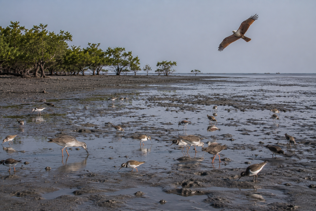
By early afternoon, the mudflats around Jambudwip begin filling with birds.
Low tide exposes feeding ground across enormous stretches of dark marine sediment. Tiny shellfish, crabs, and stranded marine organisms emerge near shallow tidal pools, drawing movement across the shoreline almost continuously.
The wildlife here does not reveal itself dramatically.
It unfolds slowly through patience.
- A line of egrets stands motionless near the water’s edge before lifting suddenly into the wind.
- Sandpipers move rapidly across wet mud, leaving delicate tracks erased minutes later by the returning tide.
- Gulls circle above fishing zones waiting for discarded catch.
Winter transforms the island’s ecological atmosphere.
Migratory birds travelling along the Bay of Bengal coastline use the tidal landscape surrounding Jambudwip as a seasonal feeding habitat. The exposed flats, shallow estuarine waters, and mangrove edges create an ideal resting ground during cooler months when marine conditions stabilize.
The sky remains constantly active.
Brahminy kites drift overhead, scanning the shore below. Terns cut sharply across tidal channels before vanishing into brighter light farther offshore. Occasionally, larger flocks wheel together above the mudflats in sudden, synchronized movement that changes the entire rhythm of the landscape for a few seconds.
But the island’s wildlife story extends beyond birds.
The mud itself is alive.
Fiddler crabs emerge everywhere once sunlight warms exposed flats after the retreating tide. Their movements create a restless shimmering effect across the shoreline. Tiny amphibious creatures move between tidal pools hidden beneath the surface until disturbed by shadow or vibration.
Near mangrove sections, the ecological mood changes again.
Roots trap sediment and organic matter washed inward from the sea. Small fish become stranded temporarily during tidal retreat. Insects gather heavily in damp areas protected from stronger coastal winds.
The mangroves function as shelter in an otherwise exposed environment.
Even reptiles adapt quietly to these conditions. Water monitors may occasionally move through isolated stretches near creeks, though sightings depend heavily on tide and disturbance. Snakes adapted to saline wetlands inhabit portions of the wider estuarine ecosystem, remaining mostly invisible beneath vegetation and mud.
Jambudwip’s wildlife rarely performs for observers. One must slow down here.
Stand still long enough and the island gradually reveals motion everywhere:
- bird tracks
- crab tunnels
- ripple patterns
- feeding marks along tidal edges
- wings flashing briefly against grey water
The surrounding marine ecosystem matters just as much as the visible shoreline.
Fish populations moving through nearby estuarine waters historically supported the entire seasonal economy of the island. Without those fisheries, Jambudwip would likely never have developed its temporary labour world at all.
And above everything remains the weather.
Cloud shadow passes continuously over the flats. Wind alters bird movement. Incoming tide reshapes feeding zones hour by hour. Even wildlife behaviour here follows the rhythm of water.
By late afternoon, the tide begins reclaiming the exposed mud.
Birds retreat gradually toward higher ground and mangrove edges. The shoreline narrows again beneath incoming water from the Bay.
The island changes shape once more.
And with it, the entire ecological landscape shifts again before sunset.
Mangrove Chronicles
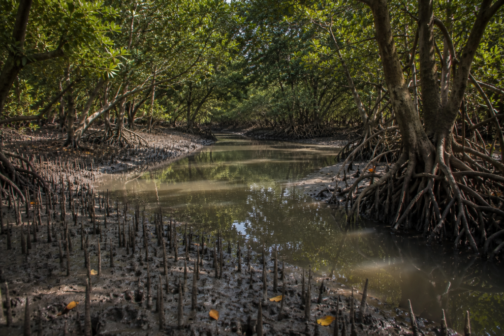
The mangroves around Jambudwip do not feel ancient in the way deeper Sundarbans forests sometimes do.
They feel defensive.
Every root appears engaged in a struggle against erosion, salt, wind, and tide.
The vegetation grows low across many sections of the island because conditions here remain intensely marine.
- Salinity stays high for much of the year.
- Cyclonic exposure damages weaker growth repeatedly.
- Strong coastal wind bends branches permanently toward the north and east.
And yet these mangroves hold the island together.
Without them, large portions of Jambudwip would likely erode far more quickly beneath tidal pressure from the Bay of Bengal.
Near the wetter creeks, roots emerge thickly from dark mud like exposed skeletal structures. Sediment gathers between them during calmer periods before storms tear sections away again. Fallen branches collect along tidal edges beside fishing debris carried inward by the current.
The relationship between people and mangroves here has always been complicated.
- Fishing communities depended partly on these coastal forests for shelter against wind and storm surge.
- Mangrove belts softened wave energy during rough weather.
- Certain wood was historically used carefully for temporary structures and fuel.
But conservation authorities increasingly viewed human activity itself as a threat to fragile coastal ecology.
That tension became central to Jambudwip’s modern story.
Walking near the mangrove edge during low tide reveals how alive these forests truly are.
- Mudskippers flick across wet sediment before disappearing into shallow water.
- Insects hum continuously beneath the leaves.
- Small crabs vanish between root systems as soon as footsteps approach.
The smell changes here too.
The open marine sharpness of the shoreline gives way to heavier organic dampness — decomposing leaves, trapped saltwater, tidal mud warming beneath filtered sunlight.
Sound behaves differently among the mangroves.
- Wind becomes softer.
- Bird calls echo strangely through the roots.
- Water drips slowly from exposed branches after the tide retreats.
Compared to the wide open flats near the coast, these areas feel enclosed and watchful.
The mangroves also preserve silence.
Outside fishing season, when temporary camps disappear and human movement fades almost entirely from the island, these forests reclaim much of the landscape.
- Birds dominate the shoreline again.
- Tidal channels flow undisturbed through the roots.
- Wind moves across empty flats carrying no smell of drying fish or diesel smoke.
The island returns briefly to ecology alone.
Then winter arrives again.
And once more, human rhythm approaches across the tide.
Explorer’s Field Notes
Field Note — Winter Morning, Low Tide
The mudflats expand quickly after sunrise.
What appeared from the boat as a narrow shoreline becomes an enormous exposed landscape stretching outward toward the Bay.
Fresh bird tracks cross the wet sediment in overlapping patterns.
Tiny pools left behind by the retreating tide reflect the pale sky like broken mirrors scattered across the flats.
The island feels larger during low tide.
And lonelier.
Field Note — Wind Direction
The marine wind rarely settles completely on Jambudwip.
By late morning, it strengthens noticeably across the exposed coast. Nets hanging near temporary bamboo frames begin snapping sharply in the air. Salt gathers visibly on rope fibres left outside for long periods.
Everything ages faster here.
Wood cracks.
Metal corrodes.
Fabric stiffens beneath salt-heavy moisture.
Field Note — Fishing Season
During active winter months, the shoreline historically transformed into a temporary industrial landscape shaped entirely by marine labour.
The process moved with astonishing speed.
Boats arrived before dawn carrying catch from nearby fishing grounds. Sorting began immediately. Fish were cleaned, salted, and spread across bamboo racks before the strongest afternoon heat arrived.
Nothing could wait long in the coastal climate.
Field Note — Bird Movement
The best bird activity often appears during the changing tide.
As water retreats, feeding zones expand across exposed sediment. Gulls gather first near fish landing areas. Smaller shorebirds move farther outward toward quieter mudflats where human disturbance remains limited.
Large flocks rarely stay still for long.
Wind direction changes their movement constantly.
Field Note — Cyclone Memory
Even on calm days, the island carries visible signs of storm exposure.
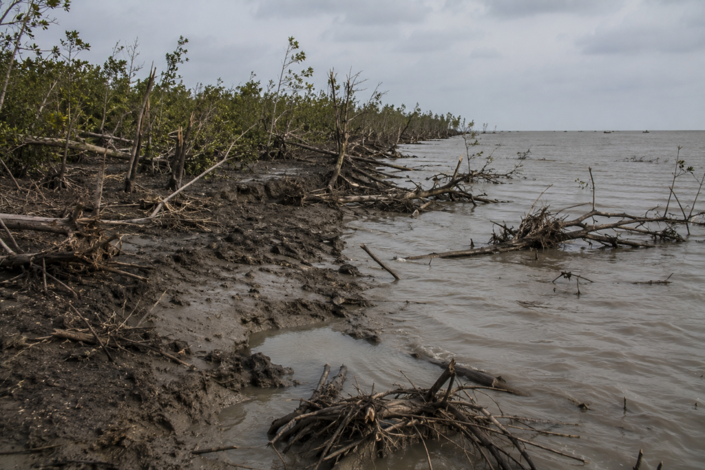
Eroded shoreline sections appear abruptly between mangrove clusters. Broken bamboo remains partly buried beneath newer sediment. Certain stretches of coast look recently cut away, as though the sea removed entire portions of land during a single violent tide.
Nothing about Jambudwip feels guaranteed.
Field Note — Afternoon Heat
By midday, exposed mud reflects sunlight upward with almost metallic intensity.
Movement slows naturally.
Workers historically used this period for repairs rather than heavy transport — stitching nets, checking ropes, reinforcing temporary shelters before the evening tide returned.
Shade remained scarce across much of the island.
Field Note — Sound After Sunset
Night changes distance.
Boat engines crossing offshore waters sound closer than they are. Wind moving through mangrove patches resembles distant rainfall. Loose bamboo poles knock rhythmically against one another long after human activity disappears.
The darkness feels tidal too.
It advances gradually across the flats until the island becomes only fragments of sound surrounded by black water.
Nightfall On The Island
Sunset arrives slowly over Jambudwip.
The light does not disappear all at once. Instead, the exposed flats hold brightness long after the sun drops lower toward the Bay. Wet mud reflects the evening sky in streaks of copper, silver, and fading blue while shallow tidal pools darken one by one beneath the incoming water.
The tide begins returning before darkness fully settles.
- Channels hidden during low water slowly refill from the sea.
- Mudbanks shrink beneath the rising current.
- Crabs disappear back into flooded holes.
- Birds retreat toward mangrove edges or lift entirely from the island before nightfall.
The landscape contracts.
By evening, the open expanses that made the island feel enormous during the afternoon begin vanishing beneath water and shadow.
During the active fishing season, this was once the busiest transition of the day.
Crews prepared for departure under fading light. Nets were checked again carefully before loading. Kerosene lamps flickered near temporary camps while cooking fires spread smoke low across the flats.
- Rice boiled in blackened metal pots.
- Fish crackled over flame.
- Men watched the tide while eating quickly before work resumed offshore.
Nothing about the evening rhythm felt leisurely.
Night fishing demanded precision.
Boats timed their departure carefully against the current and the moonlight. Stronger tides could either help movement or make navigation dangerous, depending on weather conditions farther south over the Bay.
As darkness deepened, the island changed psychologically.
During daylight, Jambudwip feels exposed.
At night, it feels isolated.
The horizon disappears almost completely except for scattered fishing lights moving slowly across distant water. Wind grows colder during the winter months. Moisture settles over ropes, nets, and bamboo structures until everything feels damp again beneath the marine air.
The sounds sharpen after sunset.
Boat engines travel enormous distances across open water. Water strikes the muddy shoreline with heavier force during a rising tide. Somewhere near the mangroves, insects begin their continuous metallic hum.
And between those sounds comes silence.
A very large silence.
There are few artificial lights here compared to permanently inhabited islands farther inland. Without settlements, markets, or road traffic, darkness takes control quickly. The sky expands overhead, uninterrupted by urban glow.
On clear winter nights, stars appear startlingly sharp above the Bay.
Older fishermen often remained awake late during difficult weather. Storm conditions could change rapidly after dark. Wind direction mattered. Tide mattered. Visibility mattered even more.
Many crews slept lightly.
Some barely slept at all before departure.
By midnight, much of the island returned again to stillness. Temporary camps dimmed into scattered lantern light barely visible against the flats. The tide continued moving invisibly through creeks and channels beneath the darkness.
And somewhere beyond the shoreline, boats crossed the black water searching for fish beneath the winter sea.
The Seasons Of The Island
Jambudwip changes personality completely with the season.
The island seen during calm winter mornings is not the same island that faces monsoon storms or cyclonic tides later in the year.
Everything here depends on the weather.
Winter is historically the season most closely associated with human activity.
From roughly October to February, cooler temperatures and calmer marine conditions allowed fishing operations to intensify around the island. The air became clearer. Offshore movement grew safer compared to the rough monsoon months. Temporary camps expanded across the flats as seasonal labour arrived from surrounding coastal settlements.
This was the island’s working season.
Morning skies stayed pale and sharp above the Bay. Migratory birds appeared across exposed mudflats. The drying wind blowing inland from the sea helped preserve fish spread across bamboo racks near the camps.
Winter gave Jambudwip rhythm.
Spring arrives subtly.
The wind grows warmer first. Haze thickens over the water by afternoon. Bird movement changes gradually as migratory populations begin departing from the coastal mudflats.
Fishing activity historically continued through parts of this transition period, though weather uncertainty slowly increased.
Then summer begins, hardening the island.
- Heat reflects fiercely from exposed sediment during low tide.
- Freshwater scarcity becomes more difficult.
- Humidity thickens across the flats until even early mornings feel heavy with marine moisture.
The landscape appears harsher during this period.
Mangrove leaves gather dust-like salt residue beneath prolonged exposure. Open ground cracks under heat before incoming tides soften them again.
By the monsoon season, Jambudwip transforms entirely.
Cloud systems move northward across the Bay in enormous dark formations visible long before rain arrives. The sea grows unpredictable. Waves strike the coast with greater force. Temporary occupation becomes increasingly difficult and dangerous.
The island feels smaller during the monsoon.
Tides remain aggressive.
Mudbanks disappear beneath continuous water movement. Rain lashes sideways across the exposed flats while wind bends mangroves almost horizontally during stronger weather systems.
Travel becomes uncertain.
Some crossings from nearby coastal settlements may become impossible during severe conditions.
Then comes cyclone season.
No other period defines the vulnerability of Jambudwip more clearly.
The island sits dangerously exposed along the northern Bay of Bengal — one of the world’s most cyclone-prone marine regions.
- Storm surges can overwhelm low coastal ground rapidly.
- Wind tears through temporary structures with little resistance.
- Shoreline erosion accelerates violently during major events.
Cyclones do not merely damage the island.
They reshape it.
After severe storms, channels may widen unexpectedly.
- Mudflats shift position.
- Mangrove sections disappear.
- Fishing infrastructure vanishes beneath surging water and debris.
And yet after the weather stabilizes, the cycle begins again.
- Winter returns.
- The sea calms.
- Fishing boats reappear on the horizon.
- Human movement slowly comes back across the tide.
Jambudwip survives through repetition.
Cyclones And Survival
Every island in the Sundarbans carries cyclone memory.
But on Jambudwip, those memories feel closer to the surface.
There are no large permanent settlements here to absorb disaster into reconstruction narratives. No concrete neighbourhoods stand visibly against storm history. The island remains open, low, and directly exposed to the Bay of Bengal.
When cyclones strike this coast, there is little protection.
Older fishermen still speak cautiously about storms that arrived faster than expected over open water. Boats caught too far offshore sometimes struggled to return before the tides turned violent. Temporary camps built for seasonal work could disappear overnight beneath the surge and wind.
The danger always came from exposure.
Strong cyclones crossing the northern Bay push seawater inland with enormous force. On low islands like Jambudwip, storm surge becomes more destructive than rainfall itself. Water overtops mudflats rapidly. Shorelines collapse. Bamboo structures break apart almost immediately beneath high wind.
Even after storms pass, the landscape rarely returns unchanged.
Certain sections of the coast show visible erosion where tidal forces removed land completely during past cyclonic events. Mangrove edges appear cut sharply in places. Driftwood and marine debris collect far inland after major surges.
The island carries physical evidence of repeated weather violence.
Cyclone Aila in 2009 affected large portions of the Sundarbans region, reshaping embankments, fisheries, settlements, and coastal ecology across South Bengal. While Jambudwip had no major permanent civilian population like inhabited islands farther inland, the wider marine economy surrounding it still experienced disruption through damaged fishing infrastructure, altered shorelines, and hazardous tidal conditions.
For fishing communities, cyclone preparation historically depended on experience more than infrastructure.
- Crews watched the sky carefully.
- Wind texture mattered.
- Cloud height mattered.
Radio warnings became increasingly important over time, but older navigators still relied heavily on environmental readings passed across generations.
- Some signs were subtle.
- A sudden silence among birds.
- Pressure change in the air.
- Wave movement behaves differently against the current.
None guaranteed safety.
But together they formed a survival language shaped by repeated exposure to the Bay.
The emotional relationship between fishermen and the weather here was never simple fear. It was respect mixed with necessity.
People returned because their livelihood demanded a return. Even after destructive storms, fishing activity resumed once conditions stabilized. Camps were rebuilt. Nets repaired. Boats were relaunched into waters still carrying debris from recent cyclones.
That resilience defines much of Jambudwip’s human history.
- Not permanence.
- Persistence.
- The island survives season by season.
So do the people connected to it.
Ferry Routes & Hidden Paths
Reaching Jambudwip has never been simple.
Even today, the journey feels less like conventional travel and more like entering a shifting marine landscape where the tide decides access long before maps do.
Most approaches begin from the mainland edge of South 24 Parganas — places like Fraserganj, Bakkhali, Namkhana, or Kakdwip, where fishing culture already shapes daily life before dawn. Harbours wake early here. Engines start in darkness. Nets are loaded under weak yellow bulbs while the smell of salt and diesel drifts through the morning air.
From Fraserganj especially, the island lies out beyond the familiar tourist coastline.
- Past the crowded beaches.
- Past the shallow recreational waters.
- Past the last permanent edge of settlement.
Then the Bay begins opening outward.
Historically, fishermen approached Jambudwip according to the tide rather than fixed schedules. Certain channels remained navigable only during rising water. Mudbanks shifted after storms. Winter crossings often appeared calm at sunrise before the afternoon wind roughened the sea unexpectedly.
Navigation here requires memory.
Not all routes were visible.
Older boatmen learned hidden tidal passages through repetition across years of seasonal movement. Some channels deepened temporarily after monsoon erosion. Others narrowed until larger boats avoided them completely.
Approaching the island during low tide could become difficult even in good weather.
Boats slowed carefully through shallow sediment zones while exposed mudflats widened rapidly around them. In certain stretches, crews historically had to disembark partially offshore and drag vessels closer through thick tidal mud before unloading supplies or catch.
The journey itself became part of island life.
Everything arriving at Jambudwip travelled by water:
- food
- fuel
- freshwater
- salt
- nets
- bamboo
- workers
- memory
Nothing came easily.
Hidden paths also existed within the island once seasonal camps expanded during active fishing months. Narrow tracks formed naturally between drying grounds, mangrove edges, temporary shelters, and landing points. After weeks of continuous movement, these routes hardened visibly beneath repeated footsteps.
Then the monsoon erased many of them again.
The island never allowed permanence for long.
Certain tidal creeks around Jambudwip also functioned as ecological corridors linking the island to wider estuarine systems across the southern Sundarbans.
- Birds moved through these channels constantly.
- Fish nurseries depended on them.
- Mangrove sediment travelled with the tide through narrow waterways barely visible from offshore.
To outsiders, the surrounding waters may appear empty.
To experienced fishermen, every channel carries an identity.
- Some are known for calmer landings.
- Some for a dangerous current.
- Some for sudden depth changes after cyclones.
The sea around Jambudwip is mapped through practical memory more than signage.
Even now, approaching the island still requires attention.
Weather shifts quickly near the Bay.
Fog can flatten visibility during winter mornings. Sudden wind changes roughen shallow water. High tide hides mudbanks that reappear hours later like emerging land.
The island remains accessible.
But never casually.
Photography Expedition Guide
The island does not offer a dramatic spectacle immediately. Its beauty emerges gradually through changing light, tide movement, weather texture, and the quiet ecological details scattered across its mudflats. Photographers arriving here expecting postcard scenery often miss what makes the island truly remarkable.
This is a place of atmosphere.
Sunrise Photography
Winter mornings produce the island’s most extraordinary light.
Before sunrise, the Bay and mudflats merge into muted silver-grey tones, broken only by silhouettes of fishing boats moving slowly through the tide. Mist occasionally hangs low over the shoreline while gulls circle above the exposed coast waiting for returning catch.
The first hour after dawn is especially rewarding.
Wet mud reflects the morning light like polished metal. Bamboo structures appear almost skeletal against the widening sky, while fishermen unloading their nets create scenes that feel closer to documentary photography than conventional coastal landscapes.
Highlights
- Fishing boat silhouettes
- Morning mist
- Gulls over the shoreline
- Reflections on wet tidal mud
- Fishermen at work
Landscape Photography
Low tide transforms Jambudwip into a vast photographic field.
Patterns emerge everywhere as the sea retreats. The uninterrupted horizon allows wide-angle compositions, while smaller details reveal the island’s quieter beauty.
Look for
- Crab trails
- Bird tracks
- Rippled sediment
- Exposed mangrove roots
- Broken shells reflecting sunlight
- Ropes beside tidal pools
A single weathered fishing net drying in the marine wind can often tell the island’s story more truthfully than a sweeping panorama.
Wildlife Photography
Winter offers the richest opportunities for bird photography.
As the tide recedes, exposed mudflats become feeding grounds for shorebirds and gulls. Early morning and late afternoon provide the softest light and the calmest conditions for observation.
Patience is essential.
Birds here react quickly to disturbance across the open landscape.
Photograph
- Shorebirds
- Gulls
- Feeding behaviour
- Birds around tidal pools
Mangrove Photography
The mangrove edges create an entirely different atmosphere.
Light filters unevenly through twisted roots and saline vegetation while tidal water reflects beneath shaded branches. During quieter hours, these areas feel suspended between land and sea.
Look for
- Twisted mangrove roots
- Reflections beneath the canopy
- Tidal pools
- Saline vegetation
- Light filtering through the mangroves
Monsoon Photography
The monsoon reveals Jambudwip at its most dramatic.
Storm clouds gather over the Bay. Wind bends the vegetation, rising tides reshape the shoreline, and the island appears raw and constantly changing beneath dark skies.
These conditions produce striking images, but strong tides and rapidly changing weather demand caution above all else.
Highlights
- Storm clouds
- Rough coastal weather
- Wind-shaped vegetation
- Rising tides
- Dark coastal skies
Sunset Photography
Sunset on Jambudwip is quiet rather than theatrical.
The light fades slowly across mud, water, and sky until the island becomes a series of silhouettes against metallic dusk. Fishing boats crossing the horizon during the evening tide often provide the day’s final memorable frame.
Then darkness arrives rapidly.
The island slowly disappears into sound and shadow.
Highlights
- Fishing boat silhouettes
- Reflections on the rising tide
- Mangroves against the evening sky
- Metallic dusk over the mudflats
- The island is fading into darkness
Expedition Notes
Jambudwip reveals itself through details that are easy to overlook at first glance.
The island rarely impresses through grand scenery. Instead, it rewards careful observation. Every tide, every gust of wind, and every change in light reveals something different about this fragile coastal landscape.
The Ground Beneath Your Feet
One of the island’s most unusual characteristics is its constantly shifting ground.
Certain stretches near the shoreline never feel completely stable beneathfoot. The sediment remains heavily saturated by tidal movement, causing the surface to shift slightly with every step. Walking across these mudflats requires a natural adjustment after only a few minutes.
Observe
- Soft tidal sediment
- Unstable mudflats near the shoreline
- Constant influence of the tide beneath the surface
A Landscape Shaped By Salt
The marine environment leaves its mark on everything.
Salt gradually accumulates on abandoned ropes, bamboo poles, and fishing equipment exposed along the coast. Metal corrodes quickly, tarpaulins fade under constant exposure, and even sturdy materials slowly surrender to the weather.
Notice
- Salt-covered ropes
- Weathered bamboo
- Corroded metal
- Faded fishing equipment
Hidden Life At Low Tide
As the sea retreats, countless small tidal pools remain scattered across the mudflats.
These shallow pools temporarily hold small fish, crabs, shell fragments, and drifting organic matter carried in by the tide. Shorebirds instinctively move from one pool to another, feeding with remarkable precision.
Look for
- Small fish
- Crabs
- Shell fragments
- Feeding shorebirds
- Temporary tidal pools
The Island Changes Colour
Light transforms Jambudwip throughout the day.
At sunrise, the mudflats appear silver-grey beneath the soft morning light. By noon, they darken to deep brown and black. Towards evening, the returning tide reflects copper and blue tones while the mangroves gradually dissolve into silhouette.
Watch for
- Silver-grey sunrise
- Brown-black afternoon mud
- Copper reflections at dusk
- Darkening mangrove silhouettes
Changing Scents
The island changes not only in appearance, but also in smell.
Morning air carries the sharp scent of marine salt. Afternoon heat intensifies the smell of fish, mud, and drying vegetation. After sunset, dampness returns, and the landscape once again smells of wet tidal earth.
The island smells of
- Marine salt
- Fish
- Tidal mud
- Drying vegetation
- Wet earth after dark
The Scale Of The Sky
Without permanent settlements or tall structures, the sky dominates almost every direction.
Weather becomes part of the landscape itself. Clouds moving inland from the Bay can be watched for long periods before they finally arrive overhead.
Storms often feel visible long before they are felt.
Observe
- Vast uninterrupted horizon
- Expansive skies
- Approaching cloud systems
- Weather moving across the Bay
Traces Of Human Presence
Outside the fishing season, the island appears almost deserted.
Yet signs of earlier activity remain scattered across the landscape—hardened pathways, weathered bamboo fragments, and old mooring points near the shore. Gradually, silence overtakes them until it becomes difficult to imagine the seasonal fishing camps that once occupied these flats.
Look for
- Old footpaths
- Bamboo fragments
- Former mooring points
- Traces of seasonal fishing activity
Between Two Worlds
Jambudwip always feels transitional.
It seems suspended between opposing forces, where neither nature nor people ever fully take possession of the landscape.
The island exists between
- Land and sea
- Occupation and abandonment
- Economy and ecology
- Memory and erosion
Perhaps that quiet uncertainty is Jambudwip’s defining characteristic.
Connected Landscapes
No island in the Sundarbans exists alone.
Jambudwip is part of a larger coastal network shaped by tide, migration, fishing routes, mangrove ecology, and marine weather moving continuously across the Bay of Bengal.
To the north and northeast lie the inhabited coastal stretches around Bakkhali, Fraserganj, Namkhana, and Kakdwip — settlements historically linked to the island through fishing movement and seasonal labour. Boats departing these harbours carried not only workers and supplies but also stories, techniques, weather knowledge, and economic dependency tied directly to the sea.
The connection was constant.
Even when Jambudwip itself remained temporarily empty, mainland communities continued orbiting around the marine economy it supported.
Farther inland, the broader Sundarbans delta spreads outward through islands divided by tidal rivers, creeks, and estuarine channels. But Jambudwip occupies a more exposed ecological position than many agricultural islands deeper inside the delta.
Here, the Bay dominates more strongly than freshwater river systems.
- Salinity increases.
- Storm exposure intensifies.
- Mangroves adapt differently.
Bird migration patterns shift closer toward marine feeding grounds.
The island also forms part of an important coastal ecological corridor. Migratory birds moving along the northern Bay of Bengal use surrounding mudflats and estuarine waters seasonally. Marine fish populations passing through nearby channels historically sustained fishing economies across multiple coastal settlements, not just temporary camps on the island itself.
Water connects everything here.
The tides carrying sediment toward Jambudwip also shape neighbouring coastlines. Cyclones affecting the island rarely strike it alone. Storm systems move across entire sections of the Sundarbans, altering embankments, fisheries, mangrove belts, and village life far beyond the immediate shoreline.
Even culturally, Jambudwip belongs to a wider maritime world.
- Fishing songs
- weather superstition
- Bonbibi belief
- boat craftsmanship
- dry-fish trade
- tidal vocabulary
All link the island to coastal Bengal communities stretching across the delta edge. The island may appear isolated from the offshore.
In reality, it exists within continuous movement.
- Birds cross daily.
- Tides cross hourly.
- Fishing boats crossed seasonally for generations.
Nothing here remains disconnected for long.
Oral Histories
Many memories of Jambudwip survive orally because the island never developed the kind of permanent civic structure that generates large written archives.
Its history travelled instead through fishermen, boatmen, traders, and seasonal workers who carried stories back to mainland settlements after each season ended.
Older fishing communities still remember the island primarily through work.
They describe winters when the shoreline filled with boats before dawn and the smell of drying fish spreads across the flats so heavily that it can be detected far offshore. Temporary camps expanded rapidly during productive seasons. Men sometimes remained for weeks at a time, depending on catch conditions and weather.
Some remember storms more vividly than labour.
Sudden wind shifts.
Boats struggling against evening tide.
Cyclonic nights when seawater pushed deep across the island, carrying nets, bamboo, and cooking equipment into darkness.
In many oral accounts, weather becomes the central character.
One recurring memory involves the silence after storms.
Older fishermen describe returning cautiously after cyclones to find sections of shoreline altered completely — channels widened, familiar landing points vanished, bamboo structures erased by surge water.
The island never guaranteed a return in the same form twice.
Certain oral histories also preserve tension surrounding conservation restrictions that intensified during the late twentieth century. Fishing families who had used the island seasonally for generations sometimes viewed newer ecological enforcement as an interruption rather than protection.
From another perspective, environmental authorities saw increasing human pressure threatening fragile mangrove systems already vulnerable to erosion and climate stress.
Both narratives continue to exist side by side.
That unresolved tension became part of the island’s living memory.
Some of the most revealing oral accounts focus not on conflict but routine:
- repairing nets beneath the winter sun
- watching tides before departure
- sharing meals inside temporary camps during rough weather
- navigating through fog before dawn crossings
These details matter because they humanize a landscape often described only through ecology or policy.
Jambudwip was never merely empty land.
For many coastal families, it formed part of an inherited survival geography tied directly to the Bay of Bengal.
Even today, mention of the island along certain fishing communities still carries emotional weight — not nostalgia exactly, but recognition.
A memory of labour at the edge of the sea.
Food Of The Island
Food on Jambudwip was never separated from labour.
Everything about eating here depended on the tide, weather, preservation, and endurance.
During the active fishing season, meals were built around practicality rather than variety. Crews arriving from coastal settlements carried rice, lentils, onions, potatoes, mustard oil, salt, dried chillies, and tea leaves packed tightly into metal containers protected from moisture during the crossing.
Freshwater mattered almost as much as food itself.
Storage barrels stood carefully covered near temporary camps because resupply depended entirely on weather and boat movement. A delayed crossing during rough seas could disrupt provisions quickly.
Cooking usually happened collectively.
Near the camps, makeshift stoves formed from stacked brick fragments or packed mud held blackened metal pots over wood fires fed by driftwood, scrap timber, or fuel carried from the mainland. Smoke moved low across the flats under the marine wind while rice boiled beside freshly cleaned fish waiting for the evening meal.
Fish dominated everything.
Not delicately prepared restaurant seafood.
Working fish.
Marine catch was cooked quickly with salt, chilli, turmeric, and mustard oil before crews returned offshore again. Smaller or damaged catch unsuitable for trade often became camp food. Some fish were dried immediately after cleaning, while others went straight into cooking pots before spoilage could begin beneath the coastal heat.
The smell defined the island.
Drying fish hanging across bamboo frames released heavy saline oil into the air from morning until dusk. Clothing absorbed it. Rope absorbed it. Even the wind seemed saturated with marine salt and fish smoke during peak activity.
Tea remained constant.
- Strong.
- Sweet.
Boiled repeatedly in dented metal kettles darkened from fire soot.
During colder winter mornings, fishermen often gathered briefly around steaming cups before sunrise departure while watching tide movement near the shore.
Food also reflected migration history.
Fishing communities connected to Jambudwip carried culinary habits from different coastal regions of Bengal, including areas historically linked to East Bengal migration after Partition. Dry fish preparation methods, spice balance, preservation techniques, and marine cooking styles travelled with people across the delta coast.
Nothing here felt ornamental.
Meals were functional fuel for physically punishing work carried out under sun, wind, salt, and unstable weather. Yet within that simplicity existed deep familiarity — the comfort of hot rice after cold dawn crossings, fish curry shared inside temporary shelters during rough weather, tea passed between exhausted crews repairing nets after sunset.
The island’s food culture belonged entirely to survival at sea.
Island Economy
Jambudwip’s economy historically revolved around one force above all others:
Marine fishing.
- Not tourism.
- Not agriculture.
- Not urban trade.
The island existed primarily as a seasonal extension of the fishing economy spreading across coastal South Bengal.
Its importance came from geography.
The surrounding waters connected directly to productive marine fishing zones in the northern Bay of Bengal, while the island itself provided open, windy ground suitable for fish drying operations during the winter months. That combination transformed Jambudwip into a temporary processing landscape supporting larger regional trade networks.
Fishing boats supplied the raw catch.
The island supplied preservation space.
During peak season, labour expanded rapidly. Fishermen, fish processors, transport workers, traders, net repairers, and boat crews all became part of a temporary economy functioning entirely through tide and weather.
Dry fish production played a major role.
Large quantities of marine catch were cleaned, salted, and spread across bamboo structures where coastal wind and sunlight gradually preserved them for transport inland. These products moved beyond the Sundarbans into markets across Bengal and neighbouring regions, where dried marine fish remained economically important.
The work demanded enormous physical effort.
- Fish had to be processed quickly.
- The weather is monitored constantly.
- Supplies protected from sudden rain or tidal flooding.
Nothing about the economy was stable.
- Storms disrupted the catch.
- Cyclones destroyed infrastructure.
- Rough seas interrupted transport.
And because the island lacked permanent settlement, every season required rebuilding temporary operational systems almost from the beginning.
Conservation restrictions later complicated this economic relationship significantly.
As ecological concerns surrounding the Sundarbans intensified, seasonal occupation and fish drying activities on Jambudwip increasingly came under environmental scrutiny. Authorities viewed the island as sensitive coastal forest territory vulnerable to ecological degradation.
Fishing communities viewed it as an inherited livelihood space.
That conflict altered the island’s economic future.
Even so, the memory of Jambudwip as a major seasonal fishing ground remains deeply embedded within coastal marine communities. Its economic influence extended far beyond the island itself because entire networks of labour, trade, migration, and family survival historically depended partly on these seasonal operations.
The island never produced wealth easily.
It produced survival through difficult work carried out at the edge of the sea.
Then & Now
Older memories of Jambudwip describe movement.
- Boats arriving before dawn.
- Smoke rising from temporary camps.
- Rows of drying fish stretching across windy flats beneath winter sunlight.
The island once carried the atmosphere of a seasonal frontier where labour transformed exposed land into a temporary economy.
Today, much of that intensity has faded.
The shoreline feels quieter now.
Mangroves reclaim certain stretches once shaped more visibly by fishing activity. Abandoned bamboo fragments emerge occasionally from the mud after erosion or storms, but long continuous seasonal occupation no longer defines the island in the same way it once did.
The transformation reflects broader changes unfolding across the Sundarbans.
- Conservation frameworks strengthened.
- Environmental vulnerability became more visible.
- Cyclones intensified public awareness of coastal fragility.
At the same time, traditional marine livelihoods across Bengal faced increasing pressure from weather instability, regulation, changing fish populations, and economic uncertainty.
Jambudwip sits directly inside those changes.
Then, the island was viewed primarily through utility.
- A place to work.
- A place to dry fish.
- A seasonal extension of the marine economy.
Now, it is increasingly viewed through ecology and vulnerability: mangrove protection, coastal erosion, climate risk, habitat conservation.
Neither version is fully complete on its own.
The island contains both histories simultaneously.
Walking here today, one can still imagine the older labour world beneath the quieter landscape. Certain hardened clearings hint at former processing zones. Landing stretches remain visibly shaped by repeated boat access over decades. The air itself still carries traces of the marine economy whenever fishing boats pass offshore.
But silence dominates more often now.
The greatest change may be emotional.
Historically, Jambudwip represented opportunity despite hardship.
Today, it feels more fragile. More temporary.
More uncertain against rising seas and increasingly violent weather patterns moving inland from the Bay of Bengal.
And yet the island remains.
- Still low against the horizon.
- Still shaped by the tide.
- Still resisting disappearance season after season.
The Wild Orbit Quick Facts
Location
Jambudwip lies near the southern edge of the Indian Sundarbans off the coast of Fraserganj and Bakkhali in the South 24 Parganas district, West Bengal.
Geographic Identity
A low-lying tidal island shaped primarily by marine fishing history, mangrove ecology, and seasonal occupation.
Administrative Region
South 24 Parganas district, West Bengal.
Ecological Zone
Part of the wider Sundarbans coastal ecosystem is influenced heavily by the Bay of Bengal.
Nearest Mainland Access
Fraserganj and Bakkhali.
Dominant Historical Identity
Seasonal fishing and dry-fish processing island.
Settlement Pattern
No major permanent civilian settlement.
Landscape
Mudflats, tidal creeks, saline mangroves, exposed shoreline, and seasonal fishing grounds.
Best Season For Exploration
Winter — especially November to February, when the weather remains comparatively stable and bird activity increases.
Wildlife Highlights
Migratory shorebirds, gulls, Brahminy kites, estuarine marine life, fiddler crabs, and mangrove ecosystem species.
Environmental Challenges
Cyclones, shoreline erosion, tidal instability, ecological pressure, salinity, and climate vulnerability.
Atmosphere
Remote, wind-beaten, seasonal, marine, transitional.
The Wild Orbit Expedition Snapshot
Accessibility
Moderate to difficult.
Access depends heavily on weather, tide, and local boat movement from coastal settlements like Fraserganj.
Wildlife Potential
Strong during winter.
Bird activity around mudflats and tidal zones becomes especially rewarding for patient observers.
Photography Potential
Exceptional for documentary, ecological, and atmospheric photography.
Best suited for photographers interested in marine labour landscapes, tidal textures, weather systems, and migratory birdlife rather than conventional scenic tourism imagery.
Cultural Richness
Subtle but deeply significant.
The island preserves the memory of seasonal fishing culture tied to coastal Bengal’s marine communities.
Historical Interest
High.
Especially for researchers exploring Sundarbans fishing history, environmental policy, seasonal labour systems, and coastal transformation.
Solitude Level
Extremely high outside seasonal activity.
Even during active periods, the island retains an exposed frontier atmosphere far removed from urban coastal tourism.
The Wild Orbit Explorer Connections
Jambudwip connects naturally to several larger Sundarbans themes and landscapes.
Fraserganj & Bakkhali
The nearest coastal gateways have historically been linked to the island through fishing routes, supply movement, and seasonal labour migration.
Namkhana & Kakdwip
Important fishing and river transport zones are connected economically and culturally to the marine world surrounding Jambudwip.
The Bay Of Bengal
More than surrounding water — the Bay shaped the island’s economy, weather, ecology, migration patterns, and vulnerability to cyclones.
Sundarbans Mangrove Ecosystem
Jambudwip forms part of the fragile coastal ecological belt where mangroves stabilize sediment and support marine biodiversity.
Seasonal Fishing Culture
The island represents one of the clearest examples of temporary marine labour landscapes historically operating within the Sundarbans region.
Migratory Bird Corridors
Winter bird movement across the northern Bay of Bengal connects the island to wider estuarine and coastal ecological systems.
Cyclone Histories
Like many exposed delta islands, Jambudwip reflects the long environmental history of storms shaping the Bengal coast.
FAQs
1. Where is Jambudwip located?
See it for yourself
A private journey shaped around you — your group, your pace, your interests. Book a free consultation.
Jambudwip lies near Fraserganj and Bakkhali in the South 24 Parganas district of West Bengal at the southern edge of the Sundarbans near the Bay of Bengal.
2. Is Jambudwip a permanently inhabited island?
No. The island historically functioned mainly as a seasonal fishing and fish-drying zone rather than a permanent civilian settlement.
3. Why is Jambudwip important?
It became historically significant for marine fishing, dry fish production, coastal ecology, and later conservation debates within the Sundarbans region.
4. Can ordinary tourists visit Jambudwip freely?
Access conditions may vary because of ecological protection regulations and local marine conditions.
5. What is the island most known for?
Seasonal fishing camps, fish drying operations, migratory birds, mudflats, and the exposed marine landscape.
6. Which season is best for exploring the island?
Winter months between November and February usually offer calmer weather and stronger bird activity.
7. How far is Jambudwip from Bakkhali?
The island lies offshore from the Bakkhali–Fraserganj coastal zone and is approached mainly by boat.
8. Does the island have mangroves?
Yes. Saline mangrove vegetation plays an important role in stabilizing sections of the island.
9. Are there tigers on Jambudwip?
The island is not primarily known as tiger territory like the deeper forest zones of the Sundarbans.
10. What kind of birds can be seen there?
Migratory shorebirds, gulls, egrets, terns, and Brahminy kites are among the commonly observed species.
11. Why did fishermen historically use the island?
The windy open landscape was ideal for drying marine fish caught in nearby Bay waters.
12. What makes the island different from other Sundarbans islands?
Its identity developed around temporary marine labour rather than permanent agriculture-based settlement.
13. Is freshwater available on the island?
Freshwater availability has historically been limited, requiring transport from mainland areas.
14. How do tides affect the island?
Tides reshape the visible shoreline daily and strongly influence landing, movement, and ecology.
15. Is the island vulnerable to cyclones?
Yes. Jambudwip is highly exposed to storms moving inland from the Bay of Bengal.
16. What kind of landscape dominates the island?
Mudflats, tidal creeks, exposed shoreline, saline vegetation, and temporary fishing grounds.
17. Was fish drying once common there?
Yes. Jambudwip historically became an important seasonal dry-fish processing zone.
18. Does the island have roads or markets?
No large permanent settlement infrastructure exists on the island.
19. What is the atmosphere of the island like?
Remote, wind-beaten, quiet, tidal, and deeply shaped by marine weather.
20. Why is Jambudwip environmentally sensitive?
Because of erosion, mangrove fragility, tidal instability, and wider Sundarbans ecological pressures.
21. What kind of photography works best there?
Documentary, ecological, bird, weather, and marine landscape photography.
22. Can the island be dangerous during the monsoon?
Yes. Strong tides, storms, and rough sea conditions make travel risky during severe weather.
23. What role did temporary camps play historically?
They supported fishermen and fish processing workers during active seasonal operations.
24. Does the island change with the season?
Dramatically. Winter and monsoon create almost entirely different environmental conditions.
25. What defines Jambudwip emotionally?
Impermanence — the feeling of a landscape continuously negotiated between human labour and the sea.
How To Reach Jambudwip
Jambudwip is an uninhabited island located off the coast of Fraserganj and Bakkhali in South 24 Parganas, West Bengal. Situated within the Sundarbans Biosphere Reserve near the Bay of Bengal, the island has restricted access due to its ecological importance and seasonal use as a fishing ground. Visitors should verify current regulations and obtain any necessary permissions before planning a journey.
From Kolkata to Fraserganj/Bakkhali:
The journey begins from Kolkata, approximately 130–140 km away. Travelers can reach the coast by either road or rail.
By Road: Drive via NH-12 and state highways through Baruipur, Joynagar, Kakdwip, Namkhana, and onward to Bakkhali and Fraserganj. The journey generally takes 4 to 5 hours, depending on traffic and weather.
By Rail: Take an Eastern Railway suburban train from Sealdah Station to Namkhana Railway Station, then continue by road to Bakkhali and Fraserganj. The opening of the Hatania–Doania Bridge has eliminated the need for the former ferry crossing, allowing uninterrupted road access to the coast.
By Boat:
Access to Jambudwip is only possible by boat, subject to official permission, weather conditions, tidal cycles, and local regulations. Boats generally operate from Fraserganj Fishing Harbour or nearby landing points when authorized. The crossing usually takes 30 to 60 minutes, depending on the departure point, tide, and sea conditions.
Because the island lies close to the open waters of the Bay of Bengal, navigation is strongly influenced by tides, shifting sandbars, and seasonal weather. Boat movements are planned around tidal windows, and trips may be postponed or cancelled if conditions are unsafe.
Travel During the Monsoon:
Between June and September, strong winds, heavy rainfall, rough seas, and cyclone activity can make boat travel hazardous. The island is generally best visited during the winter months (November to February), when sea conditions are calmer and migratory birds arrive in large numbers. Travelers should always check the latest weather forecast, tide timings, and permission requirements before arranging a visit.
Explorer Tips
Approach Jambudwip as a working marine landscape rather than a tourist destination.
The island has:
- no conventional visitor infrastructure
- no hotels
- no established tourist facilities
- limited shelter
- highly exposed weather conditions
Carry:
- drinking water
- sun protection
- waterproof storage
- tide awareness
- local navigation guidance
Most importantly, respect ecological sensitivity and local marine realities.
The island belongs first to the tide, weather, mangrove ecology, and the difficult history of coastal labour.
Things To See Around Jambudwip
The waters surrounding Jambudwip contain an entire coastal world often overlooked by travellers focused only on the more famous sections of the Sundarbans.
This landscape reveals itself slowly through harbours, tidal crossings, embankments, fishing routes, and exposed shorelines shaped by the Bay of Bengal.
Fraserganj Fishing Harbour
Before sunrise, Fraserganj becomes one of the most atmospheric locations anywhere along the southern Bengal coast.
Fishing boats gather under dim harbour lights while crews sort nets and prepare for departure into open water. Diesel smoke hangs low across the jetties. Gulls circle continuously above unloading zones where marine catch arrives with the tide.
For photographers and observers of coastal labour culture, few places feel more alive.
Bakkhali Coastline
North of the working harbour atmosphere lies the longer open coast around Bakkhali.
But beyond the tourist stretches, quieter sections reveal tidal flats, salt-heavy wind, scattered fishing activity, and long views toward the marine horizon. Winter mornings often produce extraordinary light across the coastal mud and shallow water.
The farther one walks from crowded areas, the more the landscape begins resembling the exposed ecological mood surrounding Jambudwip itself.
Namkhana Channels
The waterways around Namkhana offer insight into the larger tidal systems connecting inland delta settlements to the Bay of Bengal.
Ferries, fishing boats, cargo movement, and estuarine channels intersect constantly here. Watching tide movement from embankment edges helps explain how deeply transportation and survival in the lower Sundarbans still depend on water.
Kakdwip Fish Markets
Kakdwip remains one of the major fishing centres of coastal South Bengal.
Early morning markets reveal the economic network historically connected to islands like Jambudwip — marine catch arriving from offshore waters, traders negotiating prices rapidly, transport vehicles preparing shipments inland before the heat intensifies.
The atmosphere feels fast, wet, noisy, and intensely tidal.
Coastal Birdlife Zones
Winter brings migratory bird movement across mudflats and estuarine edges throughout the southern coast near Bakkhali and surrounding tidal stretches.
Shorebirds gather near exposed sediment during low tide, while Brahminy kites drift above fishing activity, searching for discarded catch.
The best observations usually happen quietly: standing still, watching tide, allowing the landscape to settle.
Embankments At Dusk
Some of the most revealing moments along this coast occur after sunset.
Fishing lights appear offshore.
Wind strengthens over the tidal channels.
Villages along the embankments grow quieter while the sound of distant engines continues moving invisibly through darkness toward the Bay.
This is the same marine world that shaped Jambudwip for generations.
Hidden Tidal Creeks
Smaller creeks branching through mangrove edges near the southern delta often remain absent from ordinary travel maps. Yet these waterways support fish nurseries, bird habitat, and traditional navigation routes used historically by fishing communities.
Their silence feels entirely different from the open coast.
- Closer.
- More watchful.
- More tidal.
Storm-Watching Landscapes
During pre-monsoon and monsoon periods, cloud systems gathering over the Bay create some of the most dramatic weather scenery anywhere in coastal Bengal.
The sky expands enormously over the low delta coast. Wind changes suddenly. Light shifts minute by minute across mud, water, and mangrove fringe.
These are landscapes built for observers willing to slow down.
Continue The Journey
Jambudwip is not an ending.
It is one fragment of a much larger tidal world stretching across the southern edge of Bengal.
To continue exploring this landscape means following the routes water has already drawn: through estuarine rivers, across mangrove corridors, toward fishing settlements, cyclone-shaped coastlines, and islands balancing constantly between survival and erosion.
From here, the journey naturally expands toward the inhabited islands deeper inside the Sundarbans, where embankments protect rice fields and villages from the rising tide. Places shaped more visibly by settlement reveal another side of delta existence — schools beside tidal rivers, markets built against cyclone memory, temples and mosques standing above flood lines.
Farther east, the mangrove forests themselves begin thickening.
- Creeks narrow.
- Silence deepens.
The ecological atmosphere changes from marine openness to tidal forest tension, where Bonbibi folklore and tiger memory remain deeply woven into everyday life.
Following the fishing routes northward also reveals the human geography connected to Jambudwip for generations:
- Kakdwip
- Namkhana
- Fraserganj
- Bakkhali
Small harbours where marine labour still begins before dawn.
Everywhere along this coast, the same themes repeat in different forms: weather, migration,
Erosion, adaptation, tide, uncertainty.
The Sundarbans never offers one single story.
Each island carries its own negotiation with water.
Jambudwip’s story happens to be one of the most fragile.
Where The Sea Keeps Its Silence
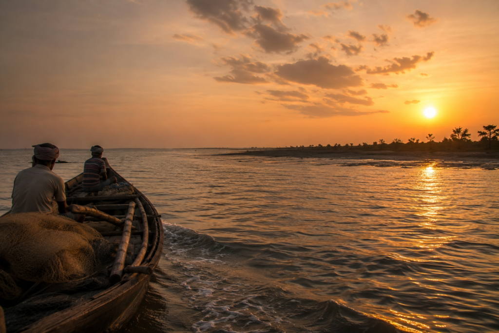
The departure usually happens with the tide.
By late evening, the shoreline begins narrowing beneath incoming water while the last light fades across the mudflats. Fishing boats move slowly offshore like dark silhouettes against the dim horizon. Wind continues crossing the island exactly as it did at dawn.
Nothing truly settles here.
As the boat pulls away from Jambudwip, the island shrinks quickly into shadow.
First, the bamboo structures disappear.
Then the mangroves flatten into darkness.
Finally, only a thin, low shape remains between sea and sky before even that dissolves into the horizon of the Bay.
What lingers afterward is not spectacle.
- Not a monument.
- Not architecture.
- Only atmosphere.
The feeling of having stood somewhere temporary.
A landscape shaped by labour yet claimed constantly by the tide. An island that survives without permanence. A place where weather still matters more than infrastructure and where silence returns each season after people leave.
Long after the shoreline disappears, the smell of salt and diesel remains on clothing.
So does the wind.
And somewhere behind the dark water, beyond the reach of mainland lights, Jambudwip continues its endless negotiation with the sea.