 Encyclopedia
Marichjhapi is a forest island in the Indian Sundarbans, within a landscape shaped by tidal rivers, creeks, mudflats and mangrove vegetation. Today, it is not an inhabited settlement or conventional tourist destination. It forms part of a protected forest landscape associated with the Sundarban Tiger Reserve, where access is regulated and human habitation inside the reserve is not permitted.
The island is also closely associated with one of the most consequential episodes in the modern human history of the Sundarbans. In 1978–79, Partition refugees established a settlement at Marichjhapi, which was subsequently cleared by the West Bengal government in 1979. That history is important, but it represents one chapter in the story of a landscape that continues to exist as forest.
Marichjhapi At a Glance
- Region: Indian Sundarbans, West Bengal
- Landscape: Forested tidal island
- Forest Context: Sundarban protected forest landscape
- Wildlife Context: Tiger habitat within the wider Sundarbans biodiversity landscape
- Accessibility: Authorised waterways only; direct public tourist access is restricted
- Nearest Major Gateway: Godkhali
- Nearest Railhead: Canning
- Nearby Inhabited Island: Kumirmari
- Present Human Settlement: No permanent residential or tourist settlement on Marichjhapi
- Historical Significance: Site of the 1978–79 refugee settlement and its eviction in 1979
How to Reach Marichjhapi
Marichjhapi does not have a normal tourist jetty, visitor centre or public sightseeing facility.
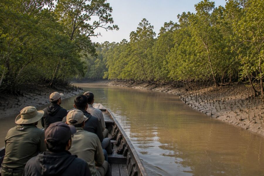
Visitors travelling through the Sundarbans generally reach the region via Canning and Godkhali, then continue by registered boat through authorised waterways.
The Sundarban Tiger Reserve requires tourists entering the reserve to use registered boats and follow prescribed routes and landing regulations.
Direct landing on Marichjhapi should not be assumed to be permitted. Current forest regulations restrict where visitors may disembark, and access can depend on the applicable forest rules and permissions.
For a visit specifically connected with Marichjhapi’s landscape or history, the route and permission requirements should be confirmed with the Forest Department or registered operator before departure.
Geographic Setting
Marichjhapi lies within the complex island-and-waterway geography of the Indian Sundarbans. The landscape is not defined by a single continuous landmass but by islands separated by tidal rivers, creeks and channels. Landforms are continually influenced by sediment deposition, tidal inundation and erosion.
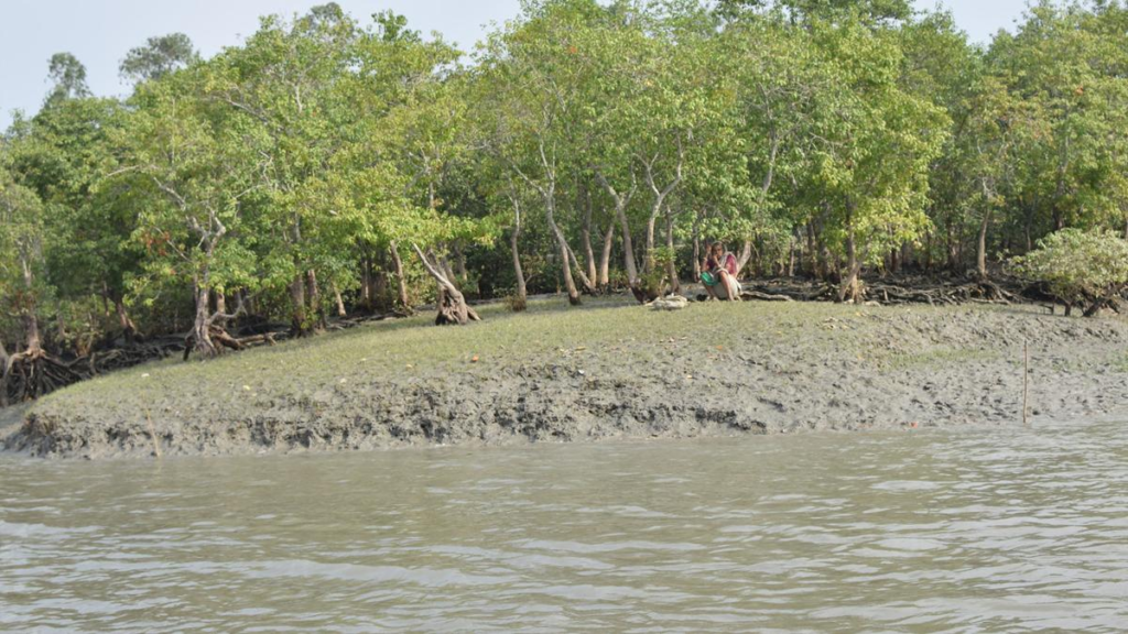
The wider area includes the Jhila forest block, part of the protected forest system of the Sundarban Tiger Reserve. The reserve’s management documents identify Jhila as a Reserved Forest block covering approximately 95 square kilometres.
Kumirmari lies among the inhabited islands along the northern fringe of the reserve and provides an important geographical reference for understanding the Marichjhapi landscape. The relationship between inhabited fringe islands and protected forest is a defining feature of this part of the Sundarbans.
Landscape Character
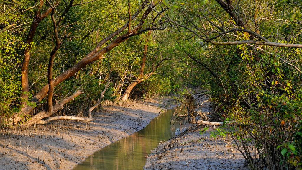
Marichjhapi is best understood as a tidal forest island, rather than as a conventional inhabited island.
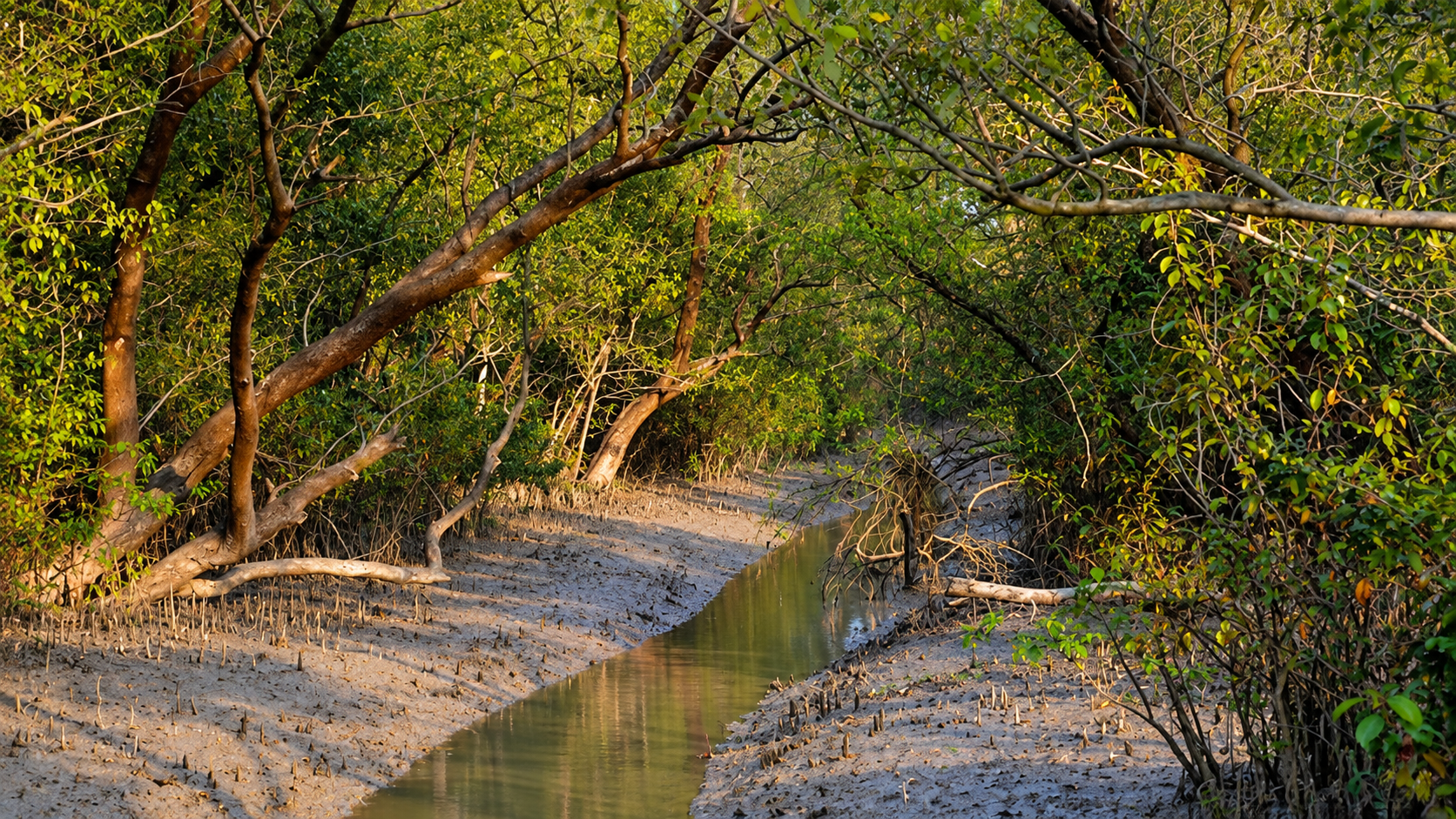
Its physical character is determined by the interaction of land and water. Tidal channels surround and penetrate the forest landscape, while low-lying ground is exposed to changing water levels and varying degrees of salinity. The wider Sundarbans has developed through long-term sediment deposition and intertidal processes, producing a landscape of islands, tidal flats, drainage channels and natural levees.
This makes the landscape dynamic. The boundaries between land and water are not permanently fixed, and the ecological character of individual forest areas can change with erosion, sedimentation, storms and changes in freshwater and salinity conditions.
Rivers and Water Systems
Water is fundamental to Marichjhapi.
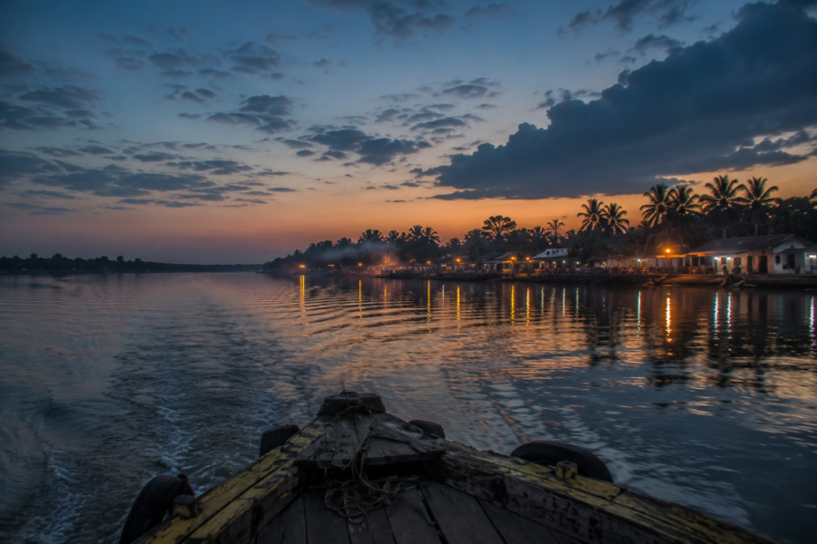
The island is reached through the same interconnected tidal water system that defines the wider Sundarbans. Rivers and creeks function simultaneously as transport routes, drainage channels and ecological corridors.
The Indian Sundarbans contains an extensive network of rivers and creeks, with water bodies occupying a substantial proportion of the forest landscape. Tides move through this network twice daily, influencing salinity, sediment movement, vegetation and the distribution of aquatic life.
For visitors, this also explains why Marichjhapi cannot be approached like a conventional land-based destination. The practical route is by authorised boat through permitted Sundarbans waterways.
Mangrove Ecosystem
The forest environment around Marichjhapi belongs to the wider mangrove ecosystem of the Sundarbans.
Mangrove vegetation is adapted to conditions that are difficult for most terrestrial plants: saline or brackish water, waterlogged soils, regular tidal flooding and unstable sediments. Across the Sundarbans, mangrove communities include species such as Avicennia, Sonneratia, Rhizophora, Ceriops and Bruguiera. Vegetation varies according to elevation, salinity, inundation and local soil conditions.
The forest therefore cannot be understood simply as a collection of trees. It is part of a functioning tidal system in which vegetation, sediment, water and wildlife are closely connected.
Wildlife
The surrounding Sundarbans supports a diverse assemblage of mammals, reptiles, birds, fish and invertebrates. The Royal Bengal Tiger (Panthera tigris) is the best-known large predator of the ecosystem and remains an important conservation focus of the Sundarban Tiger Reserve.
Other wildlife associated with the wider Sundarbans includes spotted deer (Axis axis), fishing cats, wild boar, estuarine crocodiles, water monitors, river terrapins, dolphins and numerous resident and migratory birds. Not every species occurs equally across every island or forest block, so species records should be treated at the appropriate landscape scale rather than automatically attributed to Marichjhapi itself.
For Marichjhapi, the more important point is its position within a protected forest landscape that provides habitat and movement space for wildlife.
Conservation and Protection
The present character of Marichjhapi cannot be separated from the protection regime of the Sundarbans.
The Sundarban Tiger Reserve was established in 1973, and its protected forest landscape now forms part of a larger conservation system covering approximately 2,585 square kilometres. The reserve contains core and buffer areas, with forest protection and regulated access forming central elements of its management.
The wider Sundarbans also has international conservation recognition. The Sundarbans National Park is a UNESCO World Heritage Site, recognised for its ecological and biological importance.
Today, the forest is managed primarily as a protected wildlife landscape rather than as an area for permanent human settlement. This distinction is essential when discussing Marichjhapi: the island’s present identity is that of a forest landscape, while its human settlement belongs to its modern history.
The Human History Begins Here
The forest seen today can make the events of the late 1970s difficult to imagine. Yet the present forest landscape also contains a recent human history.
In 1978, Partition refugees who had previously been directed towards the Dandakaranya resettlement region established a settlement at Marichjhapi. Contemporary and later records describe the island at that time as a Reserved Forest landscape.
That settlement, its development and its eventual eviction in 1979 form the next chapter of Marichjhapi’s history.
The forest is the present. The settlement is the history. Both are necessary to understand Marichjhapi.
History
The human history of Marichjhapi belongs largely to the decades after the Partition of Bengal. The movement of refugees from East Pakistan into India did not end in 1947; displacement continued for years, and the question of where poorer refugees would be settled became a major issue in West Bengal.
Among those affected were large numbers of Namasudra refugees, a historically marginalised agrarian community from eastern Bengal. Many had strong social, economic and cultural ties to Bengal’s deltaic environment and found the prospect of permanent resettlement far from Bengal difficult to accept.
From Partition to Marichjhapi
After Partition, refugee rehabilitation followed different paths according to economic position, occupation and government policy. While many refugees settled in West Bengal, poorer and landless families were increasingly directed towards resettlement schemes outside the state.
This eventually brought large numbers into the Dandakaranya region of central India, where the government attempted to establish permanent agricultural settlements.
For many families, however, resettlement in Dandakaranya did not resolve the underlying problem of displacement. Distance from Bengal, difficult environmental conditions, limited agricultural prospects and the loss of established social networks contributed to continuing dissatisfaction. Academic research on the period records the particular difficulties faced by lower-caste refugees in these settlements.
The Namasudra Refugees
The Marichjhapi story cannot be separated from the social identity of many of its settlers.
Namasudras had historically been associated with agriculture, fishing and other occupations connected with the waterways and wetlands of eastern Bengal. Their movement after Partition was therefore not simply a search for a place to live. Land, livelihood, community and familiarity with the delta were closely connected.
This background helps explain why the Sundarbans could appear more viable to some refugees than a distant settlement in central India. The landscape was difficult, but it was recognisably part of the Bengal delta.
The experience also had a strong caste dimension. Refugee rehabilitation did not affect all displaced Bengalis equally, and lower-caste refugees were disproportionately represented among those sent to Dandakaranya. Their later movement towards the Sundarbans became part of a wider struggle over land, rehabilitation and belonging.
The Dandakaranya Project
The Dandakaranya Development Authority was established in the 1950s as part of the Indian government’s programme for rehabilitating refugees from East Pakistan. Settlements were created across parts of present-day Odisha, Chhattisgarh and Madhya Pradesh.
The idea was to provide refugees with land and an opportunity to establish permanent agricultural communities.
For many settlers, the reality proved difficult. The new settlements were geographically distant from Bengal, and the environmental conditions differed sharply from those of the eastern delta. Water availability, agricultural productivity, infrastructure and employment were recurring concerns in accounts of refugee life in Dandakaranya.
By the 1960s and 1970s, some refugees had already begun leaving the settlements. The movement accelerated after the political change in West Bengal in 1977.
Why Many Wanted to Return to Bengal
The desire to return was shaped by more than geography.
For refugees who had spent years in Dandakaranya, Bengal represented familiar language, food systems, social networks, riverine environments and cultural belonging. Many also believed that the political change in West Bengal would create a more favourable opportunity for rehabilitation.
The Communist Party of India (Marxist) and other Left parties had previously supported refugee demands and criticised aspects of the government’s rehabilitation policy. When the Left Front came to power in West Bengal in 1977, some refugees interpreted the political change as an opportunity to return.
That expectation became an important factor in the migration that followed.
1977 and the Return to West Bengal
The Left Front government took office in West Bengal in 1977. Soon afterwards, significant numbers of refugees began leaving Dandakaranya and travelling towards Bengal.
The scale of the movement was substantial. The Kolkata Partition Museum records that by 1978 around 120,000 refugees had left Dandakaranya between January and June, selling or abandoning belongings in the hope of returning to West Bengal.
The government, however, did not ultimately support the large-scale return and settlement that many refugees expected.
Some were intercepted and sent back. Others reached different parts of West Bengal. A determined group continued towards the Sundarbans.
Arrival at Marichjhapi
By 1978, refugees began establishing themselves on Marichjhapi.
The island was attractive for practical reasons. It offered land, access to waterways and opportunities for fishing and other forms of livelihood. Its relative isolation also made it possible for refugees to establish a community with limited dependence on existing settlements.
The exact number of people who reached Marichjhapi remains disputed. Different historical sources provide substantially different estimates, so a single population figure should not be treated as definitive.
What is clear is that the settlement grew rapidly during 1978.
The refugees organised themselves rather than waiting for a formal government rehabilitation programme. The community developed houses, productive activities and basic public institutions. Contemporary and later research describes fishing, salt production, schools, health facilities and other forms of local economic activity.
Building a Community
The settlement was not simply a collection of temporary refugee shelters.
Residents cleared land, established homes and developed systems for obtaining food and water. Fishing became an important livelihood, while other activities supported the growing population.
A school was established, along with health facilities and other community institutions. Research on the settlement describes a fishing industry, salt pans, a health centre and schools created through the efforts of the settlers themselves.
These developments are important because they show that the people living on Marichjhapi were attempting to create a permanent community rather than merely passing through the island.
The settlement also developed economic relationships with nearby inhabited islands. Fishing and other products could be exchanged with communities in the surrounding Sundarbans, creating links between Marichjhapi and the existing regional economy.
Life on the Island
Daily life depended heavily on the surrounding environment.
The waterways provided fish and transport but also created practical difficulties. Fresh drinking water was limited, and the low-lying island required residents to adapt to tides, storms and waterlogging.
The community therefore modified its surroundings to make settlement possible. Embankments, ponds, homes, agricultural areas and fisheries became part of the human landscape.
This created an important transformation: a protected forest landscape was being converted into an inhabited settlement through collective labour.
That transformation would later become central to the government’s argument against the settlement.
The Settlement Becomes a Dispute
The conflict was not simply about whether refugees could remain on an island.
The government regarded Marichjhapi as protected forest land where permanent settlement was not permitted. Officials argued that continued occupation and land clearance threatened the ecological integrity of the Sundarbans. The refugees, meanwhile, regarded the island as a place where they could rebuild their lives after years of displacement.
This produced two competing claims over the same landscape.
One concerned rehabilitation, livelihood and the right to establish a home.
The other concerned forest protection and the state’s authority over protected land.
The political context made the dispute more complicated. The refugees had returned partly because of expectations created by the earlier Left opposition’s support for refugee rehabilitation, but the government in power after 1977 did not permit the Marichjhapi settlement to continue.
By late 1978 and early 1979, the disagreement had moved beyond a question of settlement policy. Government restrictions intensified, and Marichjhapi became the centre of an increasingly severe confrontation.
That confrontation forms the next part of the story.
The Government Draws a Boundary
By the end of 1978, the Marichjhapi settlement had become a direct challenge to the government’s position on protected forest land.
The West Bengal government maintained that Marichjhapi was part of the Sundarbans reserve forest and that permanent settlement and large-scale clearance could not be permitted there. The refugees, however, had already established homes, livelihoods and community institutions on the island.
The dispute therefore became both a question of land and rehabilitation and a question of forest protection and state authority.
The government began taking measures to prevent further settlement and restrict supplies reaching the island.
The Blockade
See it for yourself
A private journey shaped around you — your group, your pace, your interests. Book a free consultation.
In January 1979, restrictions around Marichjhapi intensified.
Boats carrying food and other supplies were prevented from reaching the settlement, while movement in and out of the island became increasingly difficult. The blockade became one of the defining features of the confrontation.
Accounts differ over the precise scale and duration of particular restrictions, but there is broad agreement that access to essential supplies became severely constrained.
For people living on a remote tidal island, this had immediate consequences. Food, drinking water and medical supplies could not easily be replaced from outside.
The dispute was no longer simply about whether the settlement could legally remain. Conditions on the island were becoming a humanitarian issue.
The Crisis Deepens
As the restrictions continued, reports emerged of worsening conditions among the settlers.
The geographical isolation of Marichjhapi amplified the effects of the confrontation. The settlement depended on boats for communication and the movement of goods, while the surrounding waterways made unrestricted movement difficult.
Later accounts, particularly survivor testimonies, describe shortages, illness, violence and deaths during this period. Official accounts and survivor accounts differ substantially in their description of what occurred, particularly concerning the scale of violence and the number of people who died.
Those differences are important. They are part of why Marichjhapi remains a contested historical subject.
The Court Case
The confrontation also reached the courts.
In February 1979, the Calcutta High Court intervened in response to a petition concerning the restrictions imposed on the island. On 7 February 1979, the court issued an order concerning the supply of essential commodities and the movement of people to and from Marichjhapi.
The legal intervention did not resolve the larger dispute over whether the settlement could remain permanently.
The government’s position on the occupation of protected forest land remained unchanged, and the confrontation continued.
The Final Eviction
By May 1979, the government moved to clear the settlement.
The operation took place in the middle of May, with the principal action occurring between 14 and 16 May 1979. Police and other government forces entered the island and the settlement was dismantled.
Houses and other structures were destroyed or cleared, and the residents were forced to leave.
The physical settlement that had been built during 1978 was effectively brought to an end.
What Happened During the Eviction?
This is the most difficult part of the Marichjhapi record because the available accounts do not agree.
Government accounts presented the operation primarily as the enforcement of restrictions on an unauthorised settlement in protected forest land. Survivor accounts and later investigations describe a much more violent episode, including beatings, shootings, destruction of homes and boats, and people being forced into the surrounding waterways.
There are also accounts of people dying while attempting to escape by water.
The evidence available today does not allow every individual incident to be reconstructed with certainty. Some claims come from survivor testimony recorded years after the events; others come from official records or contemporary reporting.
For that reason, the history should distinguish between documented events, testimony and disputed claims, rather than treating every account as equally established.
The Death Toll
The number of people who died at Marichjhapi remains one of the most disputed aspects of the episode.
No universally accepted death toll exists.
Government records did not acknowledge the large-scale death figures later associated with survivor accounts and other investigations. Other sources have suggested substantially higher numbers, while some estimates remain impossible to independently verify.
Several factors make an exact calculation difficult: the absence of a complete population register, the displacement of survivors, deaths that may not have been formally recorded, and the destruction or loss of relevant records.
It is therefore more accurate to state that deaths occurred during the confrontation and eviction, while the total number remains contested, rather than presenting one disputed figure as established fact.
The End of the Settlement
After the May 1979 operation, the Marichjhapi settlement ceased to exist as a permanent refugee community.
Survivors were dispersed to different locations. Some returned to earlier places of residence or rehabilitation settlements; others moved to nearby areas of the Sundarbans and elsewhere in West Bengal.
The houses, institutions and other structures created during the settlement period disappeared from the landscape.
Marichjhapi returned to the control of the forest administration, and the island once again became part of the protected forest landscape.
The confrontation had therefore produced two very different outcomes: a human settlement had disappeared, while the forest landscape remained.
The events of 1979 did not, however, end the history of Marichjhapi. The next question was what happened to the people who survived, and what became of the island after the settlement was gone.
What Happened to the Survivors?
The end of the Marichjhapi settlement did not mean the end of the people who had lived there.
After the eviction, survivors were dispersed to different parts of West Bengal and elsewhere. Some returned to earlier places of residence or rehabilitation settlements, while others remained in the Sundarbans and established lives in nearby inhabited islands and villages.
The exact movements of every family cannot be reconstructed. There was no single resettlement destination for all the people who left Marichjhapi.
For many survivors, however, the experience remained part of their personal and family history. Memories of the settlement, the eviction and the loss of homes were carried into communities outside the island.
The Settlement Disappears
The physical settlement that had developed during 1978–79 did not survive.
Homes, schools, fisheries, roads and other community structures were removed or abandoned after the eviction. Over time, most visible traces of the settlement disappeared from the landscape.
This is one reason Marichjhapi can be difficult to understand today. A visitor looking at the island does not encounter the settlement that existed there in 1978.
The absence of buildings does not mean the absence of history.
It means that the history of the settlement now survives primarily through records, photographs, oral testimony and the memories of people who lived through it.
The Landscape After 1979
After the settlement ended, Marichjhapi returned to the management of the protected forest landscape.
The island’s present appearance is therefore very different from the inhabited landscape created by the refugees. Forest vegetation now dominates the visible landscape, while the former settlement infrastructure is largely absent.
It is important, however, not to describe this simply as a complete or measurable “return of nature” without evidence. The ecological history of the island is more complicated.
Marichjhapi had a history of forest use and human modification before and during the refugee settlement, and the precise extent and character of vegetation clearance during the settlement remain subjects of historical discussion.
What can be observed today is the contrast between the inhabited settlement of 1978–79 and the protected forest landscape that exists now.
The Environmental History of Marichjhapi
The environmental history of Marichjhapi is closely connected to the central question surrounding the settlement: how should protected forest land be used?
The government argued that settlement and forest clearance were incompatible with the protection of the Sundarbans. Refugees, meanwhile, had transformed portions of the island to create homes, livelihoods and community infrastructure.
This makes Marichjhapi different from a simple story of people arriving in an empty landscape.
The island already belonged to a protected forest system. At the same time, the refugees created a functioning human landscape there within a short period.
The environmental record is also not completely uniform. Different historical accounts describe the condition of Marichjhapi before the settlement differently, including the extent of forest cover and previous human use. These differences should remain acknowledged rather than reduced to a single unquestioned version.
Marichjhapi as a Forest Landscape Today
Today, Marichjhapi is understood primarily through its relationship with the protected Sundarbans forest.
The island forms part of a landscape where mangrove vegetation, tidal waterways and wildlife habitat take precedence over permanent human settlement. The surrounding forest is managed under the protection regime of the Sundarban Tiger Reserve.
This also changes how the island can be experienced.
Marichjhapi is not an inhabited village that visitors can freely explore. Access to the reserve is regulated, boats must follow prescribed arrangements and visitors cannot simply land wherever they choose.
The presence of the Royal Bengal Tiger (Panthera tigris) and other wildlife in the wider forest landscape is one of the reasons the area requires controlled access, although individual restrictions should be understood within the wider management rules of the reserve rather than attributed solely to tiger numbers.
The Marichjhapi visible today is therefore fundamentally different from the Marichjhapi of 1978.
Memory Around the Island
Although the physical settlement disappeared, its memory remained in nearby communities and among survivors.
Kumirmari, located in the surrounding inhabited landscape, has become an important place for remembering the history of Marichjhapi. Survivor accounts, family memories and memorialisation have helped keep the episode present in local historical consciousness.
Photography and documentary projects have also contributed to preserving the record. Contemporary work has documented the island itself, survivors and surviving archival material, allowing the historical settlement to be connected with the landscape that exists today.
These sources do not all tell exactly the same story.
Official records, survivor testimony, journalism, academic research and later documentary work contain differences in emphasis and detail. Some questions remain unresolved because the surviving evidence is incomplete.
That uncertainty is part of the history rather than a reason to remove it.
Marichjhapi today is therefore a place where forest, memory and historical absence occupy the same landscape. The settlement is gone, but the island remains and understanding the difference between those two realities is essential to understanding Marichjhapi.
Marichjhapi and the History of the Sundarbans
Marichjhapi is part of two histories that cannot be separated.
One is the environmental history of the Sundarbans: a tidal forest shaped by rivers, sediment, salinity, erosion and wildlife, and increasingly managed through formal conservation systems.
The other is the human history of Bengal’s delta: migration, settlement, displacement, land reclamation and repeated attempts to establish a life in a difficult landscape.
Marichjhapi became significant because these two histories collided in the same place.
The island is therefore neither only a historical settlement nor only a forest landscape. Its significance comes from the relationship between the two.
A Refugee History
The settlement is also part of the wider history of Partition and refugee rehabilitation in eastern India.
For the Namasudra refugees who reached Marichjhapi, the island represented an attempt to establish a permanent community after years of displacement and unsuccessful rehabilitation elsewhere.
Their experience also illustrates how caste, land, livelihood and refugee policy intersected.
The history should therefore not be reduced to a simple story of migration. It was also a question of who could claim land, where displaced people could rebuild their lives, and how the state defined legitimate settlement.
Conservation and Human Displacement
Marichjhapi remains important to discussions about conservation because the conflict involved protected forest land.
The government argued that permanent settlement and forest clearance could not be permitted within the protected Sundarbans. The refugees had already established a functioning community and regarded the island as their home.
Neither side’s position can be understood without the landscape itself.
The Sundarbans is a highly dynamic and ecologically sensitive delta, but it is also a landscape that has supported human communities for generations. Marichjhapi demonstrates how difficult that relationship becomes when the boundaries between forest protection, human settlement and state control become contested.
The history therefore needs to be understood through evidence rather than reduced to a simple environmental or political explanation.
The Problem of Memory
One of the enduring difficulties in documenting Marichjhapi is the incomplete historical record.
Government documents, contemporary reporting, academic research and survivor testimony do not always agree. Population estimates differ. Accounts of the eviction differ. The number of deaths remains disputed.
This does not mean that nothing can be established.
The existence of the settlement, the government’s opposition to it, the restrictions imposed in 1979, the eviction and the subsequent disappearance of the settlement are well-established elements of the historical record.
Other details remain uncertain or contested.
A responsible account must preserve that distinction.
What the Evidence Allows Us to Say
Marichjhapi’s history contains both documented facts and unresolved questions.
It is established that refugees established a settlement on the island in 1978, that the government opposed the settlement, that restrictions intensified in early 1979 and that the settlement was cleared in May 1979.
It is also established that the physical settlement disappeared and that survivors were subsequently dispersed.
What remains more difficult to establish precisely includes the total population of the settlement, the complete sequence of individual incidents during the eviction and the total number of deaths.
Those uncertainties should not be filled with invented precision.
They are part of the reason Marichjhapi remains an important subject for continued historical research.
Why Marichjhapi Still Matters
Marichjhapi matters because its history connects several aspects of the Sundarbans that are often studied separately.
- It is a forest landscape.
- It is a conservation landscape.
- It is part of the history of Partition refugees.
- It is connected to caste and displacement.
- It is a place of contested historical memory.
Most importantly, Marichjhapi demonstrates how quickly the meaning of a landscape can change.
In 1978, people were building homes, schools and livelihoods on the island. Today, the same landscape is understood primarily as protected forest.
The island itself remains. The settlement does not.
Understanding that difference is central to understanding Marichjhapi.
The Wild Orbit’s Interesting Facts About Marichjhapi
- Marichjhapi is associated with a major refugee settlement established in 1978.
- The settlement was cleared in 1979.
- The island is now part of the protected forest landscape of the Sundarbans.
- Kumirmari is an important nearby inhabited island and geographical reference point.
- The historical population of Marichjhapi remains disputed.
- The number of deaths associated with the 1979 eviction also remains disputed.
- Contemporary photographs, survivor accounts and archival documents provide different parts of the historical record.
- Marichjhapi does not have conventional tourist infrastructure or unrestricted public access.
FAQs
What is Marichjhapi?
Marichjhapi is a forest island in the Indian Sundarbans, historically known for the refugee settlement established there in 1978 and its eviction in 1979.
Where is Marichjhapi located?
It lies within the Indian Sundarbans in West Bengal, within a wider protected forest landscape associated with the Sundarban Tiger Reserve.
What happened at Marichjhapi in 1979?
The West Bengal government moved to clear the refugee settlement after months of restrictions and confrontation. The settlement was dismantled in May 1979.
Is Marichjhapi inhabited today?
It is not a permanent inhabited settlement like nearby Kumirmari. The island is presently part of the protected forest landscape.
Can tourists visit Marichjhapi?
Marichjhapi is not a conventional tourist destination. Access through the Sundarbans is regulated, and visitors cannot assume that they can land on the island. Any specific approach should be confirmed with the Forest Department or an authorised operator.
Why is Marichjhapi historically important?
It connects the history of Partition refugees and caste with the environmental and conservation history of the Sundarbans.
Is the death toll known?
No universally accepted figure exists. Different official, journalistic, academic and survivor sources provide different accounts, and the total remains disputed.
Marichjhapi and Its Enduring Memory
Marichjhapi is easy to remember as a date.
1979.
It is harder to remember as a landscape.
- An island surrounded by tidal water.
- A community building homes after years of displacement.
- Ponds dug into difficult ground.
- Boats carrying people and supplies.
- A forest whose protection had legal and ecological significance.
- A government determined to remove an unauthorised settlement.
- A population trapped between those competing claims.
And, eventually, an island without the community that had briefly transformed it.
That is why Marichjhapi belongs in the history of the Sundarbans.
Not because it provides a simple lesson, but because it resists one.
- The forest mattered.
- The refugees mattered.
- The law mattered.
- The ecological argument mattered.
- The human consequences mattered.
And the gaps in the historical record matter too.
A responsible history does not fill those gaps with certainty simply because certainty would make the story easier to tell.
Instead, it preserves what can be established, identifies what remains disputed and allows the evidence to retain its complexity.
The Sundarbans is a landscape constantly reshaped by water, sediment, erosion and vegetation.
Marichjhapi shows that landscapes can also be reshaped by human decisions.
- A settlement can disappear.
- A forest can return.
- A community can scatter.
But memory can remain.
And sometimes the most important way to understand a place is to remember not only what stands there today, but what once stood there— and why it disappeared.
Plan your private Sundarban expedition
A private journey shaped around you — your group, your pace, your interests. Book a free consultation.